Youx
Appearance
Youx | |
|---|---|
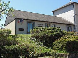
 The town hall in Youx | |
| Coordinates: 46°08′42″N 2°47′56″E / 46.145°N 2.799°E | |
| Country | France |
| Region | Auvergne-Rhône-Alpes |
| Department | Puy-de-Dôme |
| Arrondissement | Riom |
| Canton | Saint-Éloy-les-Mines |
| Intercommunality | Pays de Saint-Éloy |
| Government | |
| • Mayor (2024–2026) | Jean-Jacques Grzybowski[1] |
Area 1 | 19.13 km2 (7.39 sq mi) |
| Population (2022)[2] | 871 |
| • Density | 46/km2 (120/sq mi) |
| Time zone | UTC+01:00 (CET) |
| • Summer (DST) | UTC+02:00 (CEST) |
| INSEE/Postal code | 63471 /63700 |
| Elevation | 495–743 m (1,624–2,438 ft) (avg. 570 m or 1,870 ft) |
| 1 French Land Register data, which excludes lakes, ponds, glaciers > 1 km2 (0.386 sq mi or 247 acres) and river estuaries. | |
Youx is a commune in the Puy-de-Dôme department in Auvergne-Rhône-Alpes in central France.[3]
Geography
[edit]The river Bouble flows north-northeastward through the eastern part of the commune.
Population
[edit]| Year | Pop. | ±% p.a. |
|---|---|---|
| 1968 | 1,747 | — |
| 1975 | 1,512 | −2.04% |
| 1982 | 1,297 | −2.17% |
| 1990 | 1,115 | −1.87% |
| 1999 | 1,002 | −1.18% |
| 2007 | 1,011 | +0.11% |
| 2012 | 975 | −0.72% |
| 2017 | 915 | −1.26% |
| Source: INSEE[4] | ||
See also
[edit]References
[edit]- ^ "Jean-Jacques Grzybowski élu maire" [Jean-Jacques Grzybowski elected mayor]. lamontagne.fr (in French). 1 October 2024. Retrieved 30 November 2024.
- ^ (in French). The National Institute of Statistics and Economic Studies. 19 December 2024 https://www.insee.fr/fr/statistiques/8288323?geo=COM-63471.
{{cite web}}: Missing or empty|title=(help) - ^ INSEE commune file
- ^ Population en historique depuis 1968, INSEE
Wikimedia Commons has media related to Youx.


