Noalhat
Appearance
Noalhat | |
|---|---|
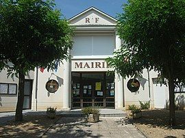
 Town hall | |
| Coordinates: 45°54′54″N 3°27′22″E / 45.915°N 3.456°E | |
| Country | France |
| Region | Auvergne-Rhône-Alpes |
| Department | Puy-de-Dôme |
| Arrondissement | Thiers |
| Canton | Maringues |
| Intercommunality | Thiers Dore et Montagne |
| Government | |
| • Mayor (2023–2026) | Ludovic Dassaud[1] |
Area 1 | 5.13 km2 (1.98 sq mi) |
| Population (2022)[2] | 230 |
| • Density | 45/km2 (120/sq mi) |
| Time zone | UTC+01:00 (CET) |
| • Summer (DST) | UTC+02:00 (CEST) |
| INSEE/Postal code | 63253 /63290 |
| Elevation | 275–356 m (902–1,168 ft) (avg. 290 m or 950 ft) |
| 1 French Land Register data, which excludes lakes, ponds, glaciers > 1 km2 (0.386 sq mi or 247 acres) and river estuaries. | |
Noalhat is a commune in the Puy-de-Dôme department in Auvergne-Rhône-Alpes in central France.[3]
See also
[edit]References
[edit]- ^ "Ludovic Dassaud a été élu maire" [Ludovic Dassaud has been elected mayor]. La Montagne (in French). 21 December 2023. Retrieved 26 September 2024.
- ^ (in French). The National Institute of Statistics and Economic Studies. 19 December 2024 https://www.insee.fr/fr/statistiques/8288323?geo=COM-63253.
{{cite web}}: Missing or empty|title=(help) - ^ INSEE commune file
Wikimedia Commons has media related to Noalhat.


