Esteio
Appearance
City of Esteio | |
|---|---|
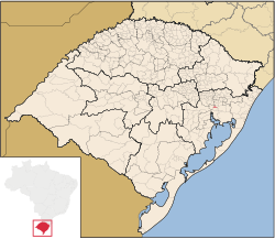
 Location in Rio Grande do Sul and Brazil | |
| Coordinates: 29°51′39″S 51°10′44″W / 29.86083°S 51.17889°W | |
| Country | Brazil |
| Region | Sul |
| State | Rio Grande do Sul |
| Founded | December 15, 1954 |
| Government | |
| • Mayor | Leonardo Duarte Pascoal (PP) |
| Area | |
• Total | 27.543 km2 (10.634 sq mi) |
| Elevation | 11 m (36 ft) |
| Population (2020 [1]) | |
• Total | 83,279 |
| • Density | 2,928.84/km2 (7,585.7/sq mi) |
| Time zone | UTC−3 (BRT) |
| HDI (2000) | 0.842 – high[2] |
| Website | esteio.rs.gov.br |
Esteio is a municipality situated in the Brazilian state of Rio Grande do Sul, in the metropolitan region of Porto Alegre, the state capital. About 9.3 miles from Porto Alegre, and neighboring Canoas and Sapucaia do Sul, it has about 83,000 inhabitants.
Esteio is known for being the city where the Expointer takes place. Expointer is one of the most important agriculture/farming fairs of South America.
See also
[edit]References
[edit]- ^ IBGE 2020
- ^ "Ranking decrescente do IDH-M dos municípios do Brasil" (in Portuguese). Atlas do Desenvolvimento Humano, Programa das Nações Unidas para o Desenvolvimento (PNUD). 2000. Archived from the original on October 3, 2009. Retrieved December 17, 2009.
External links
[edit]- Esteio Mayoral Office (Portuguese)


