Veessen
Appearance
Veessen | |
|---|---|
Village | |
 Harbour of Veessen | |
| Coordinates: 52°22′30″N 6°05′19″E / 52.3750°N 6.0886°E | |
| Country | Netherlands |
| Province | Gelderland |
| Municipality | Heerde |
| Area | |
• Total | 4.34 km2 (1.68 sq mi) |
| Elevation | 5 m (16 ft) |
| Population (2021)[1] | |
• Total | 685 |
| • Density | 160/km2 (410/sq mi) |
| Time zone | UTC+1 (CET) |
| • Summer (DST) | UTC+2 (CEST) |
| Postal code | 8194[1] |
| Dialing code | 0578 |
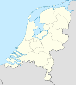
Veessen is a village in the Dutch province of Gelderland. It is located in the municipality of Heerde.
Veessen was a separate municipality between 1812 and 1818, when it was merged with Heerde.[3]
It was first mentioned in 1217 as Vesce. The etymology is unclear.[4] Veessen is an esdorp near the IJssel River. Later, it developed into a linear settlement on the dike. The Dutch Reformed has been built in 1843 as a replacement of a medieval church.[5] The Mölle van Bats is a grist mill built in 1779. A stream engine driven mill was built next to windmill in 1888.[6] In 1840, Veessen was home to 775 people.[7]
Gallery
[edit]-
Mölle van Bats
-
Statue at the harbour
-
Harbour of Veessen
-
Dutch Reformed Church
References
[edit]- ^ a b c "Kerncijfers wijken en buurten 2021". Central Bureau of Statistics. Retrieved 22 March 2022.
Two entries
- ^ "Postcodetool for 8194LA". Actueel Hoogtebestand Nederland (in Dutch). Het Waterschapshuis. Retrieved 22 March 2022.
- ^ Ad van der Meer and Onno Boonstra, Repertorium van Nederlandse gemeenten, KNAW, 2011.
- ^ "Veessen - (geografische naam)". Etymologiebank (in Dutch). Retrieved 22 March 2022.
- ^ Ronald Stenvert & Sabine Broekhoven (2000). "Veessen" (in Dutch). Zwolle: Waanders. p. 310. ISBN 90 400 9406 3. Retrieved 22 March 2022.
- ^ "Mölle van Bats". Molen database (in Dutch). Retrieved 22 March 2022.
- ^ "Veessen". Plaatsengids (in Dutch). Retrieved 22 March 2022.


