User:Universal Life/Rarh
Appearance
- Temporary convenience link to the current article Rarh region
Rarh | |
|---|---|
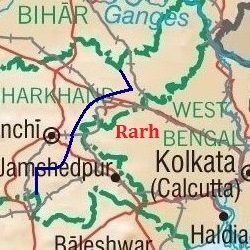
 Map showing the area of Rarh | |
| Coordinates: 23°9′0″N 87°25′12″E / 23.15000°N 87.42000°E[1] | |
| Country | |
| Region | East India |
| States | West Bengal, Jharkhand |
| Largest city | Jamshedpur |
| Most populous cities (2011)[2] | |
| Districts | 24 Districts
|
| Government | |
| • Body | Government of West Bengal, Government of Jharkhand |
| Population | |
• Estimate (2011)[3] | 56,737,000 |
| Demonym | Rarhi |
| Languages | |
| • Official | Bengali and Hindi |
| • Other languages | Angika, Odia, Ho, Kurukh, Magahi, Marwari, Mundari, Punjabi, Sadri and Santhali |
| Time zone | UTC+5:30 (IST) |
| Postal Code | |
| Vehicle registration | JH, WB |
Rarh (Bengali pronunciation: [raːɽ]) is a geographical region in the east of India that lies between the Chota Nagpur plateau on the west and the Ganges Delta on the east.[4] It is mainly coextensive with the state of West Bengal, also comprising parts of Jharkhand.
Definitions
[edit]Names and etymology
[edit]Geography
[edit]Flora and fauna
[edit]Climate
[edit]History
[edit]Demography
[edit]Economy and housing
[edit]See also
[edit]References
[edit]- ^ "Rarh". Mapcarta. Retrieved 23 August 2017.
- ^ "Most Populous Cities in India" (PDF). Census of India. Retrieved 23 August 2017.
- ^ "Census of India, 2011". Census of India. Retrieved 23 August 2017.
- ^ "Rarh". Encyclopædia Britannica. Retrieved 23 August 2017.
Bibliography
[edit]External links
[edit] Rarh travel guide from Wikivoyage


