User:Mzatwiki/Majhoul
Majhaul
مجهول मझौल | |
|---|---|
| Mojuaul | |
| Other transcription(s) | |
| • Urdu | مجہول |
| • English | Majhoul |
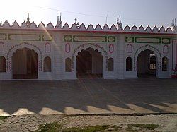
 Jama Masjid Majhaul | |
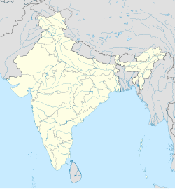
| Coordinates: 25°59′13″N 86°27′54″E / 25.987°N 86.465°E | |
| Country | |
| State | Bihar |
| Division | Kosi |
| District | Saharsa |
| Block | Nauhatta |
| Gram Panchayat | Shahpur |
| Rehabilitated | in 60's |
| Area | |
• Total | 105.75 ha (261.31 acres) |
| Elevation | 46.976 m (154.121 ft) |
| Population (2011)[1] | |
• Total | 3,698 |
| • Density | 3,500/km2 (9,100/sq mi) |
| Time zone | UTC+05:30 (IST) |
| PIN | 852123 |
| Telephone code | 06478 |
| ISO 3166 code | IN-BR |
| Vehicle registration | BR |
| Sex ratio | 927 females per 1000 males ♂/♀ |
| Language | Urdu, Hindi |
| Additional language | English |
Majhaul (or Majhoul) is a large Village in Nauhatta Block of Saharsa District of Bihar, with around 700 households in it. It is also a Revenue village with the same name. It is situated near the eastern bank of Kosi River. Majhaul is located at 167 km east from the state capital Patna and 30 km west from the district headquarter Saharsa. It is contiguous with Kumhrauli to its north, Fequrahi to the south, Telwa to the east, Kosi River to the west. Majhaul has population of about four thousand. [1]
History
[edit]Earliest available record available about Majhaul is the first cadastral survey conducted under Bengal Tenancy Act (1885).
Rehabilitation
[edit]After independence of India, the government brought a multi-purpose project for Kosi river. Due to embankment of Kosi under the project Majhaul got trapped between the embankments
Local Governence
[edit]It comes under Shahpur-Majhaul Panchayat.
Geography
[edit]The village is spread over 700-800 acres.
Demographics
[edit]It divided into 6 wards (Ward number 9 to 14). Average Sex Ratio of Majhaul village is 927 which is higher than Bihar state average of 918. Child Sex Ratio for the Majhaul as per Census of India 2011 is 977, higher than Bihar average of 935. The population has decreased by -11.4% in last 10 years.
Agriculture
[edit]Industry
[edit]Education
[edit]- Urdu Middle School, Majhaul (10120103501)
- Urdu Girl's Primary School, Majhaul East (10120102502)
- Urdu Girl's Primary School, Majhaul West (10120103503)
Land, farming and agriculture
[edit]Majhaul is situated near the Kosi River at 300 meters east to the Eastern Kosi Embankment. This makes the land very fertile. The farmers in the village mostly cultivate Dhaan (paddy crop), Makai (Maize/Corn), Gahum (Wheat crop) and Moong (a type of lentil) in their farms. Since the climate of this region is most suitable for Dhaan (the paddy crop), Makai (Maize/Corn) a good crop brings happiness to many farmers in the village. Though, people do try to grow wheat crops, only few farmers get good yields. Most of the farmers have moderate harvest and hence it is not as popular as harvesting of Dhaan (the paddy crop), Makai (Maize/Corn. Instead, maize is the first best crop for the farmers of this village and Dhaan (the paddy crop) is the second. Therefore, they are tempted to grow garma dhaan and makai (maize) crops together apart from harvesting regular crops. The timing of Dhaan harvesting is especially notable as the villagers are happy in general for several reasons. The fresh crop of Dhaan and Makai (Maize/Corn) reaches every home, Whether you are owner of the land, or the farmer or just the harvester. The Dhaan is bound to come to every household. It can be cooked straight or flattened to make Chura which makes an amazing food when combined with fresh Sakkar (Jaggery) and "Dahi" (Curd). In the rainy season (Savan aur Bhado) the whole agriculture land of this village is covered by rain water, so in this season the main food of the villagers fish and some aqua fruits.
Transport
[edit]- By Rail
There is no railway station near to Majhaul in less than 10 km. Saharsa Junction railway station is the nearest railway station. How ever Darbhanga Junction railway station is major railway station 67 km near to Majhaul.
- By Road
Saharsa are the nearby towns to Majhaul having road connectivity by Bus.
See also
[edit]
References
[edit]- ^ a b c Saharsa, District Census Handbook (2011). District Census Handbook Saharsa Part B. Patna: Directorate of Census Operations, Bihar. p. 56. Retrieved 28 June 2022.


