User:Hurricanefan24/Hurricane Chantal (1989)
Appearance
| Category 1 hurricane (SSHWS/NWS) | |
| Formed | July 30, 1989 |
|---|---|
| Dissipated | August 3, 1989 |
| Highest winds | 1-minute sustained: 80 mph (130 km/h) |
| Lowest pressure | 984 mbar (hPa); 29.06 inHg |
| Part of the 1989 Atlantic hurricane season | |
http://www.nhc.noaa.gov/archive/storm_wallets/atlantic/atl1989-prelim/chantal/
Meteorological history
[edit]
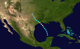
Map key
Tropical depression (≤38 mph, ≤62 km/h)
Tropical storm (39–73 mph, 63–118 km/h)
Category 1 (74–95 mph, 119–153 km/h)
Category 2 (96–110 mph, 154–177 km/h)
Category 3 (111–129 mph, 178–208 km/h)
Category 4 (130–156 mph, 209–251 km/h)
Category 5 (≥157 mph, ≥252 km/h)
Unknown
Tropical storm (39–73 mph, 63–118 km/h)
Category 1 (74–95 mph, 119–153 km/h)
Category 2 (96–110 mph, 154–177 km/h)
Category 3 (111–129 mph, 178–208 km/h)
Category 4 (130–156 mph, 209–251 km/h)
Category 5 (≥157 mph, ≥252 km/h)
Unknown
Storm type
Chantal's origins were first detected as a perturbation on the Intertropical Convergence Zone (ITCZ) close to Trinidad, just off the coast of South America on July 24. The disturbance moved westward through the Caribbean without much further development prior to its arrival in Honduras on July 27, when the National Hurricane Center (NHC) began issuing reports on the system. Satellite imagery indicated distinct outflow, though forecasters were believed the chance of formation could be impeded by its closeness to land. Hence, development at the time was expected to be gradual.[1]
Preparations and impact
[edit]See also
[edit]References
[edit]- ^ Gerrish, Harold P. (1989-11-22). "Preliminary Report – Hurricane Chantal". National Oceanic and Atmospheric Administration. Miami, Florida: National Hurricane Center. p. 1. Retrieved 2012-04-23.
- ^ "HURDAT 1851–2011". Atlantic Oceanographic and Meteorological Laboratory. Miami, Florida: Hurricane Research Division. 2012. Retrieved 2012-04-23.

