User:EncMstr/sandbox
Settlement by pioneers
[edit]

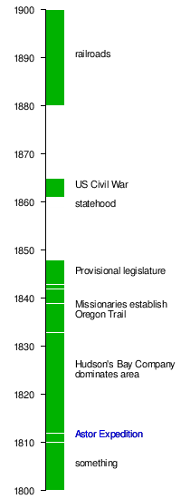
The Astor Expedition of 1810–1812, financed by American businessman John Jacob Astor, brought fur traders to the future site of Astoria by both land and sea.[1] Fort Astoria was the first permanent white settlement in the region. Although the fort would remain under American control for only a short time, it would become a significant component of the United States' later claim on the region.[citation needed] A party returning east discovered the South Pass through the Rocky Mountains, which would become an important feature of the Oregon Trail.

In the War of 1812, the British gained control of all of the Pacific Fur Company posts.[citation needed] By the 1820s and '30s, their Hudson's Bay Company dominated the Pacific Northwest from its Columbia District headquarters at Fort Vancouver (built in 1825 by the District's Chief Factor John McLoughlin across the Columbia from present-day Portland).
In the 1830s, several parties of Americans traveled to Oregon, further establishing the Oregon Trail. Many of these emigrants were missionaries seeking to convert natives to Christianity. Jason Lee was the first, traveling in Nathaniel Jarvis Wyeth's party in 1833 and establishing the Oregon Mission in the Willamette Valley; the Whitmans and Spaldings arrived in 1847, establishing the Whitman Mission east of the Cascades. In 1839 the Peoria Party embarked for Oregon from Illinois.
In 1841, wealthy master trapper and entrepreneur Ewing Young died without a will, and there was no system to probate his estate. A probate government was proposed at a meeting after Young's funeral. Doctor Ira Babcock of Jason Lee's Methodist Mission was elected Supreme Judge. Babcock chaired two meetings in 1842 at Champoeg (half way between Lee's mission and Oregon City) to discuss wolves and other animals of contemporary concern. These meetings were precursors to an all-citizen meeting in 1843, which instituted a provisional government headed by an executive committee made up of David Hill, Alanson Beers, and Joseph Gale. This government was the first acting public government of the Oregon Country before American annexation.
The Oregon Trail brought many new settlers to the region, starting in 1842–1843, after the United States agreed to jointly settle the Oregon Country with the United Kingdom. For some time, it seemed the United States and the United Kingdom would go to war for a third time in 75 years (see Oregon boundary dispute), but the border was defined peacefully in 1846 by the Oregon Treaty. The border between the United States and British North America was set at the 49th parallel. The Oregon Territory was officially organized in 1848.

Numerous efforts to find easier overland passage to the Willamette Valley were undertaken beginning in the 1840s. The Barlow Road, Meek Cutoff, and Applegate Trail represented efforts to cross the Cascades in the northern, central, and southern parts of Oregon, respectively. The Barlow Road would become the final leg of the Oregon Trail after its construction in 1846, and the Santiam Wagon Road would cut through the central part of the mountains, succeeding where Meek had failed.
Settlement increased because of the Donation Land Claim Act of 1850, in conjunction with the forced relocation of the native population to Indian reservations in Oregon. The state was admitted to the Union on February 14, 1859.
At the outbreak of the American Civil War, regular U.S. troops were withdrawn and sent east. Volunteer cavalry were recruited in California and sent north to Oregon to keep peace and protect the populace. The First Oregon Cavalry served until June 1865.
In the 1880s, the proliferation of railroads assisted in marketing of the state's lumber and wheat, as well as the more rapid growth of its cities. This included the connection of the state to the Eastern United States via links to the transcontinental railroads that allowed for faster movement of goods and people. Immigration to Oregon increased after the connection to the east. Additional transportation improvements included the construction of several locks and canals to ease river navigation.
- ^ Loy, William G. (2001). Atlas of Oregon. University of Oregon Press. pp. 12–13. ISBN 0-87114-102-7.
{{cite book}}: Unknown parameter|coauthors=ignored (|author=suggested) (help)
