Tobed
Appearance
Tobed | |
|---|---|
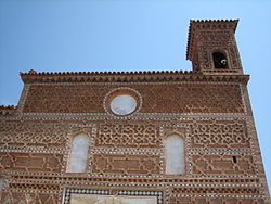
 Church of Santa María de Tobed | |
 | |
| Country | Spain |
| Autonomous community | Aragon |
| Province | Zaragoza |
| Area | |
• Total | 37 km2 (14 sq mi) |
| Elevation | 638 m (2,093 ft) |
| Population (2018)[1] | |
• Total | 214 |
| • Density | 5.8/km2 (15/sq mi) |
| Time zone | UTC+1 (CET) |
| • Summer (DST) | UTC+2 (CEST) |
Tobed is a municipality located in the province of Zaragoza, Aragon, Spain. As of 2018, the municipality had a population of 214 inhabitants.[2]
This town is located between the Sierra de Vicort and the Sierra de Algairén in the Grio River valley.
References
[edit]- ^ Municipal Register of Spain 2018. National Statistics Institute.
- ^ Tobed Territorio Mudéjar
41°20′N 1°24′W / 41.333°N 1.400°W


