Tekoa Mountain (Washington)
Appearance
| Tekoa Mountain | |
|---|---|
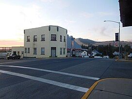
 Tekoa, Washington, with Tekoa Mountain in the background | |
| Highest point | |
| Elevation | 4,009 ft (1,222 m) |
| Coordinates | 47°15′30″N 117°05′23″W / 47.25833°N 117.08972°W |
| Geography | |
Tekoa Mountain is a 4,009-foot (1,222 m)[1] summit 2.5 miles (4.0 km) north of Tekoa, just south of the Spokane County–Whitman County line in the U.S. state of Washington. It is the highest point in Whitman County.[2][3] The peak is used as a launch site by hang gliding enthusiasts except when it is closed for fire danger.[4]
References
[edit]- ^ United States Geological Survey 1:24,000 topographic quad o47117c1 "Tekoa Mountain", 1980
- ^ "Washington County High Points - Peakbagger.com". www.peakbagger.com. Retrieved August 31, 2022.
- ^ "Scenic features", Palouse Scenic Byway official website, Pullman, Washington: Pullman Chamber of Commerce, retrieved May 9, 2018
- ^ Rich Landers (June 15, 2014). "Spokane group ministers for free-flight sports". The Spokesman-Review. Spokane, Washington. Retrieved May 9, 2018.
External links
[edit]


