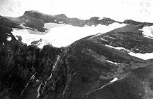
Swiftcurrent Glacier
Appearance


| Swiftcurrent Glacier | |
|---|---|
 Swiftcurrent Glacier in September 2019 | |
| Type | Cirque glacier |
| Location | Glacier National Park, Glacier County, Montana, U.S. |
| Coordinates | 48°46′07″N 113°44′50″W / 48.76861°N 113.74722°W[1] |
| Area | 55.233 acres (223,520 m2)in 2005[2] |
| Status | Retreating |
Swiftcurrent Glacier is in Glacier National Park in the U.S. state of Montana.The glacier is on the east (Glacier County) side of the Continental Divide arête known as the Garden Wall.[3] Swiftcurrent Glacier is one of several glaciers that are being monitored to determine stream flow alterations that occur due to glacial retreat.[4] Compared to other glaciers in Glacier National Park, Swiftcurrent Glacier has experienced relatively slow retreat. As of 2005, the glacier had an area of 55 acres (0.22 km2), a 14 percent reduction since 1966.[2]
See also
[edit]References
[edit]- ^ "Swiftcurrent Glacier". Geographic Names Information System. United States Geological Survey, United States Department of the Interior. Retrieved September 1, 2012.
- ^ a b "Retreat of Glaciers in Glacier National Park" (PDF). United States Geological Survey. 2010. Retrieved September 1, 2012.
- ^ Many Glacier, MT (Map). TopoQwest (United States Geological Survey Maps). Retrieved September 1, 2012.
- ^ "Monitoring and Assessing Glacier Changes and Their Associated Hydrologic and Ecologic Effects in Glacier National Park". Secondary Glacier Network. United States Geological Survey. August 2011. Archived from the original on December 17, 2007. Retrieved September 1, 2012.

