Sveti Vid, Cerknica
Sveti Vid
Žilce (1955–1991) | |
|---|---|
 | |
| Coordinates: 45°51′2.9″N 14°27′37.72″E / 45.850806°N 14.4604778°E | |
| Country | |
| Traditional region | Inner Carniola |
| Statistical region | Littoral–Inner Carniola |
| Municipality | Cerknica |
| Area | |
• Total | 1.47 km2 (0.57 sq mi) |
| Elevation | 844.4 m (2,770.3 ft) |
| Population (2020) | |
• Total | 46 |
| • Density | 31/km2 (81/sq mi) |
| [1] | |
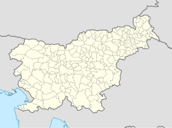
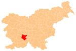
Sveti Vid (pronounced [ˈsʋeːti ˈʋiːt]; in older sources also Žilče pri svetem Vidu,[2] German: Schilze bei Sankt Veit[2] or Schülze[3]) is a small village in the hills northeast of Begunje in the Municipality of Cerknica in the Inner Carniola region of Slovenia.[4]
Name
[edit]Under Austria-Hungary, the settlement was officially known as Žilče pri svetem Vidu (German: Schilze bei Sankt Veit),[2][5] but in the Kingdom of Yugoslavia it was known as Sveti Vid (literally, 'Saint Vitus') and the name Žilče was used for a hamlet of the settlement.[6] The name of the settlement was changed from Sveti Vid nad Cerknico (literally, 'Saint Vitus above Cerknica') to Žilce in 1955. The name was changed on the basis of the 1948 Law on Names of Settlements and Designations of Squares, Streets, and Buildings as part of efforts by Slovenia's postwar communist government to remove religious elements from toponyms. The name was changed back to Sveti Vid in 1991.[7][8][9]
Church
[edit]The local parish church, from which the settlement gets its name, is dedicated to Saint Vitus and belongs to the Roman Catholic Archdiocese of Ljubljana.[10]
References
[edit]- ^ Statistical Office of the Republic of Slovenia
- ^ a b c Leksikon občin kraljestev in dežel zastopanih v državnem zboru, vol. 6: Kranjsko. 1906. Vienna: C. Kr. Dvorna in Državna Tiskarna, p. 122.
- ^ Kozler, Peter. 1854. Kratek slovenski zemljopis in pregled politične in pravosodne razdelitve Ilirskega kraljestva in Štajerskega vojvodstva. Vienna: Leopold Sommer, p. 47.
- ^ Cerknica municipal site
- ^ Weixelburg und Zirknitz (map, 1:75,000). 1912. Vienna: K.u.k. Militärgeographisches Institut.
- ^ Krajevni leksikon Dravske Banovine. 1937. Ljubljana: Zveza za tujski promet za Slovenijo, p. 395.
- ^ Spremembe naselij 1948–95. 1996. Database. Ljubljana: Geografski inštitut ZRC SAZU, DZS.
- ^ Premk, F. 2004. Slovenska versko-krščanska terminologija v zemljepisnih imenih in spremembe za čas 1921–1967/68. Besedoslovne lastnosti slovenskega jezika: slovenska zemljepisna imena. Ljubljana: Slavistično društvo Slovenije, pp. 113–132.
- ^ Urbanc, Mimi, & Matej Gabrovec. 2005. Krajevna imena: poligon za dokazovanje moči in odraz lokalne identitete. Geografski vestnik 77(2): 25–43.
- ^ Družina RC Church in Slovenia Journal website
External links
[edit] Media related to Sveti Vid at Wikimedia Commons
- Sveti Vid on Geopedia


