Suan Phueng district
Suan Phueng
สวนผึ้ง | |
|---|---|
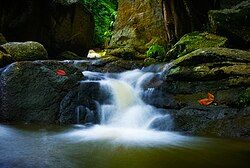
 Kaeng Som Maew, a large stone islet in the Phachi River | |
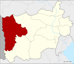
 District location in Ratchaburi province | |
| Coordinates: 13°32′36″N 99°20′24″E / 13.54333°N 99.34000°E | |
| Country | Thailand |
| Province | Ratchaburi |
| Seat | Suan Phueng |
| Area | |
• Total | 1,005.08 km2 (388.06 sq mi) |
| Population (2017) | |
• Total | 52,637 |
| • Density | 52.37/km2 (135.6/sq mi) |
| Time zone | UTC+7 (ICT) |
| Postal code | 70180 |
| Geocode | 7003 |
Suan Phueng (Thai: สวนผึ้ง, pronounced [sǔa̯n pʰɯ̂ŋ]) is a district (amphoe) in the western part of Ratchaburi province, western Thailand.
History
[edit]Suan Phueng was the rural area of Chom Bueng district. It became a minor district (king amphoe) on 15 November 1974, consisting of the three tambons: Suan Phueng, Pa Waim, and Ban Bueng.[1] It was upgraded to a full district on 1 April 1983.[2]
Etymology
[edit]The name Suan Phueng (lit. 'bee garden') originates from Phueng trees (Ficus albipila) that are found in the district. In these trees bees (Thai: phueng) often build hives.
Geography
[edit]Neighboring districts are (from the north clockwise): Mueang Kanchanaburi and Dan Makham Tia of Kanchanaburi province; and Chom Bueng and Ban Kha of Ratchanburi Province. To the west is the Tanintharyi Division of Myanmar.
The important water resource is the Phachi River.
Administration
[edit]The district is divided into four sub-districts (tambons), which are further subdivided into 37 villages (mubans). There are two sub-district municipalities (thesaban tambons) within the district. Suan Phueng covers parts of tambon Suan Phueng, and Ban Chat Pa Wai covers parts of tambons Pa Wai and Tha Khoei.
| 1. | Suan Phueng | สวนผึ้ง | |
| 2. | Pa Wai | ป่าหวาย | |
| 4. | Tha Khoei | ท่าเคย | |
| 7. | Thanao Si | ตะนาวศรี |
The missing numbers are the tambon which now form Ban Kha minor district.
References
[edit]- ^ ประกาศกระทรวงมหาดไทย เรื่อง แบ่งท้องที่อำเภอจอมบึง จังหวัดราชบุรี ตั้งเป็นกิ่งอำเภอสวนผึ้ง (PDF). Royal Gazette (in Thai). 91 (185 ง): 3972. November 5, 1974. Archived from the original (PDF) on May 4, 2012.
- ^ พระราชกฤษฎีกาตั้งอำเภอเทพสถิต อำเภอวังน้ำเย็น อำเภอเนินมะปราง อำเภอสวนผึ้ง และอำเภอเสนางคนิคม พ.ศ. ๒๕๒๖ (PDF). Royal Gazette (in Thai). 100 (50 ก special): 10–12. March 31, 1983. Archived from the original (PDF) on July 18, 2011.
External links
[edit]
