Sovra
Appearance
Sovra | |
|---|---|
 | |
| Coordinates: 46°1′9″N 14°6′48″E / 46.01917°N 14.11333°E | |
| Country | |
| Traditional region | Upper Carniola |
| Statistical region | Upper Carniola |
| Municipality | Žiri |
| Area | |
• Total | 1.48 km2 (0.57 sq mi) |
| Elevation | 497.7 m (1,632.9 ft) |
| Population (2002) | |
• Total | 13 |
| [1] | |
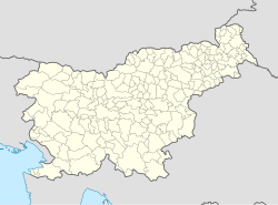
Sovra (pronounced [ˈsoːu̯ɾa]) is a small settlement in the Municipality of Žiri in the Upper Carniola region of Slovenia. It lies in the valley of Žirovnica Creek, a tributary of the Poljane Sora, south of the town of Žiri.[2]
Name
[edit]Sovra was attested in written sources as Zaevr in 1318, Sewre in 1453, and Soure in 1500, among other spellings.[3] The name of the village is originally a hydronym, sharing its name with the Sovra River, as the Poljane Sora is known in its upper course. The name is derived from the common noun *ső̜vьra with the original meaning 'flashy stream' or 'confluence'.[4]
References
[edit]- ^ Statistical Office of the Republic of Slovenia
- ^ Žiri municipal site
- ^ "Sovra". Slovenska historična topografija. ZRC SAZU Zgodovinski inštitut Milka Kosa. Retrieved September 28, 2021.
- ^ Snoj, Marko (2009). Etimološki slovar slovenskih zemljepisnih imen. Ljubljana: Modrijan. p. 389.
External links
[edit] Media related to Sovra at Wikimedia Commons
- Sovra on Geopedia


