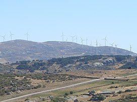
Sierra de Ávila
Appearance
| Sierra de Ávila | |
|---|---|
 Cerro de Gorría | |
| Highest point | |
| Elevation | 1,708 m (5,604 ft) |
| Coordinates | 40°39′25″N 4°59′03″W / 40.65694°N 4.98417°W |
| Geography | |
 | |
| Location | Iberian Peninsula, Spain |
| Geology | |
| Rock type | Granite |
The Sierra de Ávila is a mountain range in the centre of the Iberian Peninsula. Its highest point is Cerro de Gorría, at 1708 metres.[1]
See also
[edit]References
[edit]- ^ "Principales cumbres montañosas de la provincia de Ávila". www.ign.es (in Spanish). Instituto Geográfico Nacional. Archived from the original on January 6, 2013. Retrieved March 20, 2015.
