Shin-Tanna Tunnel
Appearance
 新丹那トンネル / Shin-Tanna Tunnel | |
| Overview | |
|---|---|
| Line | Tōkaidō Shinkansen |
| Location | between Kannami town and Atami town |
| Coordinates | 35°6′26.7186″N 138°59′28.0026″E / 35.107421833°N 138.991111833°E |
| Status | active |
| Operation | |
| Opened | 1964 |
| Operator | Central Japan Railway Company |
| Traffic | Railway |
| Character | Passenger and Freight |
| Technical | |
| Line length | 7,959 m (26,112 ft) |
| No. of tracks | 2 |

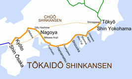
Shin-Tanna Tunnel (新丹那トンネル, Shin-Tanna tonneru) is a tunnel on the Tōkaidō Shinkansen that runs from Kannami town and Atami town in Shizuoka city, Shizuoka Prefecture with total length of 7.959 km (4.945 mi). It was built and completed in 1964 located parallel to the old Tanna Tunnel.[1][2][3][4]
See also
[edit]- List of tunnels in Japan
- Seikan Tunnel undersea tunnel between Honshu-Hokkaido islands
- Kanmon Railway Tunnel undersea tunnel between Honshu-Kyushu islands
- Sakhalin–Hokkaido Tunnel
- Bohai Strait tunnel
References
[edit]- ^ Shin-Tanna Tunnel
- ^ "List of railway tunnels in Japan". Retrieved 17 October 2023.
- ^ "新丹那トンネル". yahoo maps. Retrieved 17 October 2023.
- ^ "Shin-Tanna tunnel" (PDF). Retrieved 17 October 2023.
