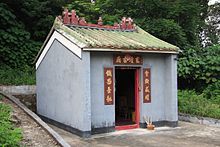
Shek Mun Kap
Appearance
Shek Mun Kap | |
|---|---|
Village | |
 Entrance gate of Shek Mun Kap | |
 |


Shek Mun Kap (Chinese: 石門甲) is a village in the Tung Chung area of Lantau Island, Hong Kong.
Administration
[edit]Shek Mun Kap is a recognized village under the New Territories Small House Policy.[1]
References
[edit]- ^ "List of Recognized Villages under the New Territories Small House Policy" (PDF). Lands Department. September 2009.
Further reading
[edit]- Hamilton, Eric; Schofield, Walter; Peplow, S. H.; Tsui, Paul; Coates, Austin; Hayes, James (2010). Strickland, John (ed.). Southern District Officer Reports: Islands and Villages in Rural Hong Kong, 1910-60. Hong Kong University Press. pp. 78–79. ISBN 9789888028382.
External links
[edit]Wikimedia Commons has media related to Shek Mun Kap.
- Delineation of area of existing village Shek Mun Kap (Tung Chung) for election of resident representative (2019 to 2022)
- Antiquities Advisory Board. Historic Building Appraisal. Entrance Gate, Shek Mun Kap Pictures
22°16′08″N 113°55′54″E / 22.26902°N 113.93167°E
