Saraphi district
Saraphi
สารภี | |
|---|---|
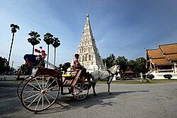
 Wat Chedi Liam, a part of greater Wiang Kum Kam archaeology site | |
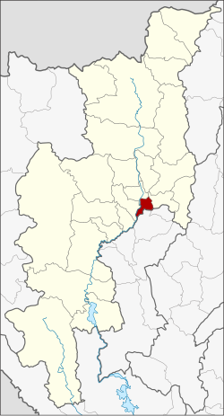
 District location in Chiang Mai province | |
| Coordinates: 18°42′48″N 99°2′11″E / 18.71333°N 99.03639°E | |
| Country | Thailand |
| Province | Chiang Mai |
| Area | |
• Total | 97.45 km2 (37.63 sq mi) |
| Population (2005) | |
• Total | 74,782 |
| • Density | 767.4/km2 (1,988/sq mi) |
| Time zone | UTC+7 (ICT) |
| Postal code | 50140 |
| Geocode | 5019 |
Saraphi (Thai: สารภี) is a district (amphoe) of Chiang Mai province, northern Thailand.
Etymology
[edit]Saraphi is the Thai name for a tree, Mammea siamensis.
Geography
[edit]Saraphi borders the districts (from west clockwise) Hang Dong, Mueang Chiang Mai, San Kamphaeng of Chiang Mai Province, Mueang Lamphun of Lamphun province.
History
[edit]The district was established in 1891, then named Yang Noeng (ยางเนิ้ง). In 1927 it was renamed Saraphi.
Tourism
[edit]Wiang Kum Kam is at the site of an old city in the Tha Wang Tan sub-district. King Mangrai lived there for ten years before the founding of Chiang Mai. The site includes many ruined temples which are often visited by visitors of Chiang Mai.
Administration
[edit]The district is divided into 12 sub-districts (tambons), which are further subdivided into 105 villages (mubans). Yang Noeng is a township (thesaban tambon) which covers parts of tambons Yang Noeng, Saraphi, and Nong Phueng. The township Saraphi covers parts of tambon Saraphi. There are a further 10 tambon administrative organizations (TAO).
| No. | Name | Thai name | Villages | Pop. | |
|---|---|---|---|---|---|
| 1. | Yang Noeng | ยางเนิ้ง | 7 | 8,964 | |
| 2. | Saraphi | สารภี | 9 | 6,959 | |
| 3. | Chom Phu | ชมภู | 9 | 6,873 | |
| 4. | Chai Sathan | ไชยสถาน | 8 | 4,567 | |
| 5. | Khua Mung | ขัวมุง | 10 | 5,510 | |
| 6. | Nong Faek | หนองแฝก | 9 | 5,271 | |
| 7. | Nong Phueng | หนองผึ้ง | 8 | 11,429 | |
| 8. | Tha Kwang | ท่ากว้าง | 7 | 2,856 | |
| 9. | Don Kaeo | ดอนแก้ว | 7 | 3,913 | |
| 10. | Tha Wang Tan | ท่าวังตาล | 13 | 9,299 | |
| 11. | San Sai | สันทราย | 12 | 5,635 | |
| 12. | Pa Bong | ป่าบง | 6 | 3,506 |
See also
[edit]References
[edit]External links
[edit]
