Saraavesi
Appearance
You can help expand this article with text translated from the corresponding article in Finnish. (March 2022) Click [show] for important translation instructions.
|
| Saraavesi | |
|---|---|
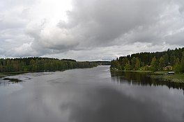
 Saraavesi as seen from Liisanniemi bridge | |
| Coordinates | 62°25′N 025°59′E / 62.417°N 25.983°E |
| Primary inflows | Kuusaankoski, Tarvaalanvirta |
| Primary outflows | Kuhankoski |
| Catchment area | Kymijoki |
| Basin countries | Finland |
| Surface area | 10.488 km2 (4.049 sq mi) |
| Average depth | 5.79 m (19.0 ft) |
| Max. depth | 39.85 m (130.7 ft) |
| Water volume | 0.061 km3 (49,000 acre⋅ft) |
| Shore length1 | 62.5 km (38.8 mi) |
| Surface elevation | 84.7 m (278 ft) |
| Frozen | December–April |
| Settlements | Laukaa |
| References | [1] |
| 1 Shore length is not a well-defined measure. | |
Saraavesi is a medium-sized lake in Laukaa, Finland. It flows to lake Leppävesi via Kuhankoski rapids. The lake is part of Keitele Canal, a waterway connecting Lake Keitele and Päijänne.[2] Saraakallio rock paintings are located on the shore of Saraavesi.[3]
Several parts of the lake are included in the Natura 2000 protection program. There include the shallow lake Peukaloinen, Saraakallio rocks, eskers, Tarvaalanvirta and Kuusaankoski rapids and some cultural heritage places.[4]

See also
[edit]References
[edit]- ^ "Saraavesi (14.321.1.001)". Järviwiki. Finnish Environment Institute. Retrieved 24 August 2012.(in English)
- ^ Via Keitele Canal from Lake Päijänne to Lake Keitele. Retrieved 2014-02-19.
- ^ Visiting Saraakallio rock paintings. Jyväskylä University. Retrieved 2014-02-19.(in English)
- ^ Vatianjärven-Saraaveden suojelualue. Environment Authority of Finland. Retrieved 2014-02-20. (in Finnish)
External links
[edit] Media related to Lake Saraavesi at Wikimedia Commons

