
Salman Shahr
Salman Shahr
سلمانشهر | |
|---|---|
City | |
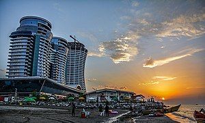
 Salman Shahr in 2018 | |
 Salman Shahr | |
| Coordinates: 36°42′21″N 51°11′51″E / 36.70583°N 51.19750°E[1] | |
| Country | Iran |
| Province | Mazandaran |
| County | Abbasabad |
| District | Salmanshahr |
| Population (2016)[2] | |
| • Total | 9,656 |
| Time zone | UTC+3:30 (IRST) |
| Website | salmanshahr |
Salman Shahr (Persian: سلمانشهر)[a] is a city in, and the capital of, Salmanshahr District[b] of Abbasabad County, Mazandaran province, Iran.[5] It is 30 kilometres (19 mi) east of Tonekabon en route to the city of Chalus.
Demographics
[edit]Population
[edit]At the time of the 2006 National Census, the city's population was 9,592 in 2,605 households, when it was in the former Abbasabad District of Tonekabon County.[6] The following census in 2011 counted 8,654 people in 2,560 households,[7] by which time the district had been separated from the county in the establishment of Abbasabad County. The city was transferred to the new Kelarabad District.[5][c] The 2016 census measured the population of the city as 9,656 people in 3,057 households,[2] when the district's name had changed to Salmanshahr District.[4]
Economy
[edit]This section needs additional citations for verification. (May 2023) |
This section may need to be rewritten to comply with Wikipedia's quality standards. (May 2023) |
Tourism is an important part of the city's economy.[8] In the late 2000s the major development and construction projects called "Qoo" or "Diamond of the Middle East" were kicked off. The core of these projects is built in the same place as where Motel Qoo was located. This vast complex of commercial, residential, tourist, sports, and entertainment include a 5-star hotel, two residential and commercial towers, a sports complex, and a six-story parking garage that is built in the form of a giant ship. This project has a total land area of 43,263 m2 (465,680 sq ft), where 173,000 m2 (1,860,000 sq ft) of it will be constructed as follows:
- Residential high rise of Negin Pooya: Includes twin towers of 25 floors with 300 units of residential apartments.
- Commercial high rise of Negin Poorya: Composed of three floors with its own entrance separate independent and separate from that of the residential tower.
- 5-star deluxe international hotel of Swan: 35 floors containing 337 rooms.
Gallery
[edit]-
 Salman Shahr beach in August 2011
 -
 Motel Qu in November 2019


See also
[edit]Notes
[edit]- ^ Also romanized as Salmānŝahr; formerly known as Motel Ghoo or Motel Qu (متل قو)[3]
- ^ Formerly Kelarabad District[4]
- ^ Renamed Salmanshahr District[4]
References
[edit]- ^ OpenStreetMap contributors (19 October 2024). "Salman Shahr, Abbasabad County" (Map). OpenStreetMap (in Persian). Retrieved 19 October 2024.
- ^ a b Census of the Islamic Republic of Iran, 1395 (2016): Mazandaran Province. amar.org.ir (Report) (in Persian). The Statistical Center of Iran. Archived from the original (Excel) on 7 October 2021. Retrieved 19 December 2022.
- ^ Salman Shahr can be found at GEOnet Names Server, at this link, by opening the Advanced Search box, entering "-3075910" in the "Unique Feature Id" form, and clicking on "Search Database".
- ^ a b c Rahimi, Mohammad Reza (c. 2023) [Approved 11 September 2011]. Divisional reforms in Mazandaran province. qavanin.ir (Report) (in Persian). Ministry of the Interior, Defense Political Commission of the Government Board. Proposals 5622/42/1/4, 144980/42/4/1, and 40794/42/1/4. Archived from the original on 22 May 2023. Retrieved 22 May 2023 – via Laws and Regulations Portal of the Islamic Republic of Iran.
- ^ a b Davodi, Parviz (c. 2023) [Approved 3 March 1388]. Divisional reforms and changes in Mazandaran province. qavanin.ir (Report) (in Persian). Ministry of the Interior, Board of Ministers. Proposal 154154/42/4/1. Archived from the original on 20 May 2023. Retrieved 20 May 2023 – via Laws and Regulations Portal of the Islamic Republic of Iran.
- ^ Census of the Islamic Republic of Iran, 1385 (2006): Mazandaran Province. amar.org.ir (Report) (in Persian). The Statistical Center of Iran. Archived from the original (Excel) on 20 September 2011. Retrieved 25 September 2022.
- ^ Census of the Islamic Republic of Iran, 1390 (2011): Mazandaran Province. irandataportal.syr.edu (Report) (in Persian). The Statistical Center of Iran. Archived from the original (Excel) on 19 January 2023. Retrieved 19 December 2022 – via Iran Data Portal, Syracuse University.
- ^ "متل قو، شهری میان جنگل و دریا". خبرگزاری مهر | اخبار ایران و جهان | Mehr News Agency (in Persian). 1 October 2019. Retrieved 16 January 2020.
| Authority control databases: Geographic |
|---|
| Capital | |||||||||||||||||
|---|---|---|---|---|---|---|---|---|---|---|---|---|---|---|---|---|---|
| Districts |
| ||||||||||||||||
This Abbasabad County location article is a stub. You can help Wikipedia by expanding it. |