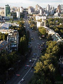
Povitrianykh Syl Avenue
Appearance
 View of Povitrianykh Syl Avenue | |
| Native name | Проспект Повітряних Сил (Ukrainian) |
|---|---|
| Length | 6.3 km (3.9 mi) |
| Location | Kyiv, Ukraine Shevchenkivskyi and Solomianskyi districts |
Povitrianykh Syl Avenue (Ukrainian: Проспект Повітряних Сил) is a street located in Shevchenkivskyi District and Solomianskyi District of Kyiv. It runs from Viacheslava Chornovola Street to Kyiv International Airport.
History
[edit]Povitryanykh Syl Avenue appeared in the middle of the 19th century as a road to Zhuliany. Since 1848, the Cadet Highway,[1] from which the building of the Kyiv Cadet Corps (1848-1857) is located at the beginning of the highway and now houses the Ministry of Defense. Then the highway started from Lvivska Street (now Sichovykh Striltsiv Street) and reached the current Ivana Ohiienka Street.
References
[edit]- ^ План земельного участка по Кадетскому шоссе, отведенного под постройку Кадетского корпуса. 1848 г. // State Archive of Kyiv Oblast, ф. 1542, оп. 1, спр. 47.
