Portal:Weather/Selected article
Selected article 1
Portal:Weather/Selected article/1

Recently selected articles: Ice Storm of 1998, More...
Selected article 2
Portal:Weather/Selected article/2

The deadliest and most destructive natural disaster to ever hit the lakes, the storm killed over 250 people, destroyed 19 ships, and stranded 19 others. It produced 6-foot drifts of snow in the surrounding land areas, snapped power poles, and paralyzed many areas for days, especially the area around Cleveland, Ohio.
The financial loss in water-bound vessels alone was nearly $5 million, or about $100 million in present-day adjusted dollars. The large loss of cargo, including coal, iron ore, and grain, meant short-term rising prices for consumer products throughout North America.
Recently selected articles: Extratropical cyclone, Ice Storm of 1998, More...
Selected article 3
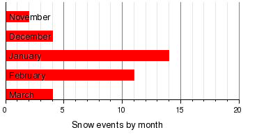
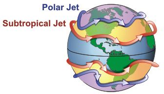
Portal:Weather/Selected article/3 Snow events are a rarity in the U.S. state of Florida, as freezing temperatures in the state are generally caused by the cold and dry winds of anticyclones. Most of the state is in a rare portion of the continental United States which receives a mean maximum monthly snowfall amount of zero, the only other such areas being southern Texas and California. However, snow does occur, especially in the northern interior sections of the state, sometimes more than once in a season. Areas near Jacksonville have seen several inches of snow on occasion, and snow flurries have been reported as far south as Homestead. Generally, for snow to occur, the polar jet stream must move southward through Texas and into the Gulf of Mexico, with a stalled cold front across the southern portion of the state curving northeastward to combine freezing air into the frontal clouds.
Recently selected articles: Great Lakes Storm, Extratropical cyclone, More...
Selected article 4
Portal:Weather/Selected article/4 A surface weather analysis is a type of weather map which provides a view of weather elements at a specified time based on information from ground-based weather stations. Weather maps are created by plotting or tracing the values of relevant quantities such as sea level pressure, temperature, and cloud cover onto a geographical map to help find synoptic scale features such as weather fronts.
The first weather maps in the 19th century were drawn well after the fact to help devise a theory on storm systems. After the advent of the telegraph, simultaneous observations of weather became possible for the first time, and beginning in the late 1840s, the Smithsonian Institution became the first organization to draw real-time surface analyses. Use of surface analyses began first in the United States, spreading worldwide during the 1870s. Use of the Norwegian cyclone model for frontal analysis began in the late 1910s across Europe, with its use finally spreading to the United States during World War II.
Surface weather analyses have special symbols which show frontal systems, cloud cover, precipitation, or other important information. For example, an H may represent high pressure, implying good and fair weather. An L on the other hand may represent low pressure, which frequently accompanies precipitation. Various symbols are used not just for frontal zones and other surface boundaries on weather maps, but also to depict the present weather at various locations on the weather map. The surface weather analysis is useful for visualizing general trends in the weather across a relatively large geographic area.

Recently selected articles: Snow in Florida, Great Lakes Storm, More...
Selected article 5
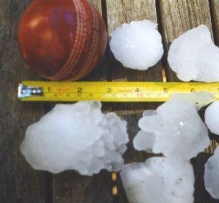
Portal:Weather/Selected article/5 The 1999 Sydney hailstorm was the costliest natural disaster in Australian history, causing extensive damage along the east coast of New South Wales. The storm developed south of Sydney on the afternoon of April 14, 1999 and struck the city's eastern suburbs, including the central business district, later that evening.
The storm dropped an estimated 500,000 tonnes of hailstones in its path. Insured damages caused by the storm were over A$1.7 billion, with the total damage bill (including uninsured damages) estimated to be around A$2.3 billion, equivalent to US$1.5 billion. It was the costliest in Australian history in terms of insured damages, overtaking the 1989 Newcastle earthquake that had resulted in A$1.1 billion in insured damages. Lightning also claimed one life during the storm, and the event caused approximately 50 injuries.
The storm was classified as a supercell following further analysis of its erratic nature and extreme attributes. During the event, the Bureau of Meteorology was consistently surprised at the frequent changes in direction, as well as the severity of the hail and the duration of the storm. The event was very unusual, as the time of year and weather conditions in the region were not conducive for a severe thunderstorm to form.
Previously selected articles: Surface weather analysis, Snow in Florida, More...
Selected article 6
Portal:Weather/Selected article/6 Global warming is the increase in the average temperature of the Earth's near-surface air and oceans in recent decades and its projected continuation.
The global average air temperature near the Earth's surface rose 0.74 ± 0.18 °C (1.33 ± 0.32 °F) during the 100 year period ending in 2005. The Intergovernmental Panel on Climate Change (IPCC) concludes "most of the observed increase in globally averaged temperatures since the mid-20th century is very likely due to the observed increase in anthropogenic greenhouse gas concentrations" via the greenhouse effect. Natural phenomena such as solar variation combined with volcanoes probably had a small warming effect from pre-industrial times to 1950 and a small cooling effect from 1950 onward. These basic conclusions have been endorsed by at least 30 scientific societies and academies of science, including all of the national academies of science of the major industrialized countries. While individual scientists have voiced disagreement with the conclusions of the IPCC, the overwhelming majority of scientists working on climate change are in agreement with the conclusions.
Climate model projections summarized by the IPCC indicate that average global surface temperature will likely rise a further 1.1 to 6.4 °C (2.0 to 11.5 °F) during the 21st century. The range of values results from the use of differing scenarios of future greenhouse gas emissions as well as models with differing climate sensitivity. Although most studies focus on the period up to 2100, warming and sea level rise are expected to continue for more than a thousand years even if greenhouse gas levels are stabilized. The delay in reaching equilibrium is a result of the large heat capacity of the oceans.
Increasing global temperature will cause sea level to rise, and is expected to increase the intensity of extreme weather events and to change the amount and pattern of precipitation. Other effects of global warming include changes in agricultural yields, trade routes, glacier retreat, species extinctions and increases in the ranges of disease vectors.
Remaining scientific uncertainties include the amount of warming expected in the future, and how warming and related changes will vary from region to region around the globe. There is ongoing political and public debate worldwide regarding what, if any, action should be taken to reduce or reverse future warming or to adapt to its expected consequences. Most national governments have signed and ratified the Kyoto Protocol, aimed at reducing greenhouse gas emissions and outside of the United States there is considerably less debate over the effects and uncertainties of global warming.

Recently selected articles: 1999 Sydney hailstorm, Surface weather analysis, More...
Selected article 7
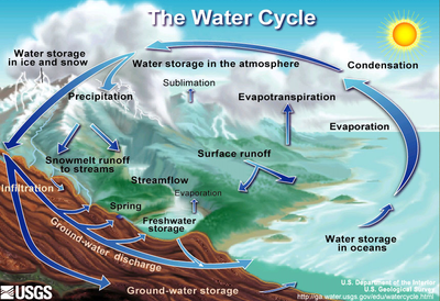
Portal:Weather/Selected article/7 The water cycle, also known as the hydrologic cycle, describes the continuous movement of water on, above, and below the surface of the Earth. Since the water cycle is truly a "cycle," there is no beginning or end. Water can change states among liquid, vapor, and ice at various places in the water cycle, with these processes happening in the blink of an eye or over millions of years. Although the balance of water on Earth remains fairly constant over time, individual water molecules can come and go in a hurry.
Recently selected articles: Global warming, 1999 Sydney hailstorm, More...
Selected article 8
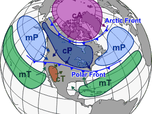
Portal:Weather/Selected article/8 A weather front is a boundary separating two masses of air of different densities, and is the principal cause of meteorological phenomena. In surface weather analyses, fronts are depicted using various colored lines and symbols, depending on the type of front. The air masses separated by a front usually differ in temperature and humidity. Cold fronts may feature narrow bands of thunderstorms and severe weather, and may on occasion be preceded by squall lines or dry lines. Warm fronts are usually preceded by stratiform precipitation and fog. The weather usually clears quickly after a front's passage. Some fronts produce no precipitation and little cloudiness, although there is invariably a wind shift.
Cold fronts and occluded fronts generally move from west to east, while warm fronts move poleward. Because of the greater density of air in their wake, cold fronts and cold occlusions move faster than warm fronts and warm occlusions. Mountains and warm bodies of water can slow the movement of fronts. When a front becomes stationary, and the density contrast across the frontal boundary vanishes, the front can degenerate into a line which separates regions of differing wind velocity, known as a shearline. This is most common over the open ocean.
Recently selected articles: Water cycle, Global warming, More...
Selected article 9
Portal:Weather/Selected article/9 A jet stream is a fast flowing, relatively narrow air current found at the tropopause, the transition between the troposphere (where temperature decreases with height) and the stratosphere (where temperature increases with height). Jet streams are typically located at 10-15 kilometers above the surface of the Earth. They form near boundaries of adjacent air masses with significant differences in temperature, such as the polar region and the warmer air to the south. The path of the jet typically has a meandering shape, and these meanders known as Rossby waves. Rossby waves propagate westward with respect to the flow in which they are embedded, which translates to a slower eastward migration across the globe than smaller scale short wave troughs. The major jet streams are westerly winds (flowing west to east) in the Northern Hemisphere.
During the summer, low-level easterly jets can form in tropical regions. A southerly low level jet in the Great Plains of North America helps fuel overnight thunderstorm activity, normally in the form of mesoscale convective systems. A similar northerly low-level jet can form across Australia, instigated by cut-off lows which develop across southwest portions of the country.
Meteorologists use the location of the jet stream as an aid in weather forecasting. The main commercial use of the jet stream is during airline travel, as flying long distances along the jet stream can cut hours off a long distance trip. One type of clear-air turbulence is found in the jet stream's vicinity, which can be a hazard to aircraft. One future benefit of the jet stream could be to augment power generation within the next 10 to 20 years, if technological hurdles can be overcome.
Recently selected articles: Weather front, Water cycle, More...
Selected article 10
Portal:Weather/Selected article/10 The 1933 Atlantic hurricane season was the second most active Atlantic hurricane season on record, with 21 storms forming during that year in the northwest Atlantic Ocean. The season ran through the summer and the first half of fall in 1933, and was only surpassed in total number of tropical cyclones by the 2005 season, which had 28 storms. The 1933 season saw tropical activity before its start, and a tropical cyclone was active for all but 13 days from June 28 to October 7. Tropical cyclones that did not approach populated areas or shipping lanes, especially if they were relatively weak and of short duration, may have remained undetected. Because technologies such as satellite monitoring were not available until the 1960s, historical data on tropical cyclones from this period are often not reliable. Compensating for the lack of comprehensive observation, one hurricane researcher estimates the season produced 24 tropical cyclones.
Ten of the season's 21 storms attained hurricane status. Five of those were major hurricanes, with sustained winds of over 111 miles per hour (179 km/h); the strongest reached peak winds of 150 miles per hour (240 km/h) near the Bahamas in early October. The season produced several deadly storms, with eight storms killing more than 20 people. All but one of the 21 known storms affected land at some point during their lifetimes.
Recently selected articles: Jet Stream, Weather front, More...
Selected article 11
Portal:Weather/Selected article/11
Recently selected articles: 1933 Atlantic hurricane season, Jet stream, More...
Selected article 12
Portal:Weather/Selected article/12
Recently selected articles: Cyclogenesis, 1933 Atlantic hurricane season, More...
Selected article 13
Portal:Weather/Selected article/13
Recently selected articles: Weather, Cyclogenesis, More...
Selected article 14
Portal:Weather/Selected article/14

Recently selected articles: Hurricane Vince, Weather, More...
Selected article 15
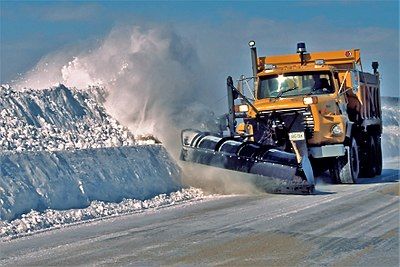
Portal:Weather/Selected article/15 A winter service vehicle (WSV), or snow removal vehicle, is used to clear thoroughfares of ice and snow. Winter service vehicles are usually based on dump truck chassis, with adaptations allowing them to carry specially designed snow removal equipment. Many authorities also use smaller vehicles on sidewalks, footpaths, and cycleways. Road maintenance agencies and contractors in temperate or polar areas often own several winter service vehicles, using them to keep the roads clear of snow and ice and safe for driving during winter. Airports use winter service vehicles to keep both aircraft surfaces, and runways and taxiways free of snow and ice, which, besides endangering aircraft takeoff and landing, can interfere with the aerodynamics of the craft.
The earliest winter service vehicles were snow rollers, designed to maintain a smooth, even road surface for sleds, although horse-drawn snowploughs and gritting vehicles are recorded in use as early as 1862. The increase in motor car traffic and aviation in the early 20th century led to the development and popularisation of large motorised winter service vehicles.
Recently selected articles: Hurricane Mitch, Hurricane Vince, More...
Selected article 16
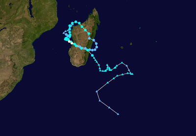
Portal:Weather/Selected article/16 Cyclone Elita was an unusual tropical cyclone that made landfall on Madagascar three times. The fifth named storm of the 2003–04 South-West Indian Ocean cyclone season, Elita developed on January 24 in the Mozambique Channel. It strengthened to become a tropical cyclone before striking northwestern Madagascar on January 28. Elita weakened to tropical depression status while crossing the island, and after exiting into the southwest Indian Ocean it turned to the west and moved ashore for a second time on January 31 in eastern Madagascar. After crossing the island, the cyclone intensified again after reaching the Mozambique Channel, and Elita turned to the southeast to make its final landfall on February 3 along southwestern Madagascar. By February 5 it had undergone extratropical transition, and the remnants of Elita moved erratically before dissipating on February 13.
Elita dropped heavy rainfall of over 200 mm (8 inches), which damaged or destroyed thousands of houses in Madagascar. Over 50,000 people were left homeless, primarily in Mahajanga and Toliara provinces. Flooding from the storm damaged or destroyed more than 450 km² (170 sq mi) of agricultural land, including important crops for food. Across the island, the cyclone caused at least 33 deaths, with its impact further compounded by Cyclone Gafilo about two months later. Elsewhere, the cyclone brought rainfall and damage to Mozambique and Malawi, while its outer circulation produced rough seas and strong winds in Seychelles, Mauritius, and Réunion.
Recently selected articles: Winter service vehicle, Hurricane Mitch, More...
Selected article 17
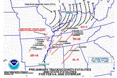
Portal:Weather/Selected article/17 The 2008 Super Tuesday tornado outbreak was a deadly tornado outbreak which affected the Southern United States and the lower Ohio Valley on February 5–6, 2008. In total, 87 tornadoes were confirmed in the outbreak's 15 hour span. Several destructive tornadoes struck heavily populated areas, most notably in the Memphis metropolitan area, in Jackson, Tennessee, and the northeastern end of the Nashville metropolitan area. Fifty-seven people were killed in the outbreak by tornadoes across four states and 18 counties, with hundreds injured and property damage totaling more than $500 million (USD).
The outbreak was the deadliest in the U.S. since the May 31, 1985 outbreak that killed 76 across Ohio and Pennsylvania (and also killed 12 in Ontario, Canada). It also was the deadliest tornado outbreak in both Tennessee and Kentucky since the 1974 Super Outbreak. In addition to the tornadoes, the same system produced significant straight-line wind damage, hail as large as softballs, or 4.50 inches (11 cm) in diameter, major flooding, significant freezing rain, and heavy snow across many areas of eastern North America.
Recently selected articles: Cyclone Elita, Winter service vehicle, More...
Selected article 18
Portal:Weather/Selected article/18 In meteorology, precipitation is a term for any product of the condensation of atmospheric water vapour that is deposited on the Earth's surface. It occurs when the atmosphere, becomes saturated with water vapour and the water condenses, falling out of solution. Two processes, possibly acting together, can lead to air becoming saturated: cooling the air or adding water vapour to the air. Precipitation forms via collision with other rain drops or ice crystals within a cloud.
Precipitation that reaches the surface of the earth can occur in many different forms, including rain, freezing rain, drizzle, ice needles, snow, ice pellets or sleet, graupel and hail. While snow and ice pellets require temperatures to be near or below freezing at the surface, hail can occur during much warmer temperature regimes due to the process of its formation. Precipitation also occurs on other celestial bodies—including snow on Mars and a sulfuric acid rain on Venus—though both of these evaporate before reaching the surface.
Moisture overriding associated with weather fronts is a major method of precipitation production. If enough moisture and upward motion is present, precipitation falls from convective clouds such as cumulonimbus and can organize into narrow rainbands. Precipitation can also form due to forced ascent up the windward side of a mountain or mountain range. Precipitation is a major component of the water cycle, and is responsible for depositing essentially all of the fresh water on the planet. Approximately 505,000 km3 (121,000 cu mi) of water falls as precipitation each year; 398,000 km3 (95,000 cu mi) of it over the oceans.

Recently selected articles: Super Tuesday tornado outbreak, Cyclone Elita, More...
Selected article 19
Portal:Weather/Selected article/19

A subtropical cyclone is a weather system that has some characteristics of a tropical and an extratropical cyclone. As early as the 1950s, meteorologists were unclear whether they should be characterized as tropical or extratropical cyclones. They were officially recognized by the National Hurricane Center in 1972. Subtropical cyclones began to receive names from the official tropical cyclone lists in the Atlantic Basin in 2002.
There are two definitions currently used for subtropical cyclones. Across the north Atlantic and southwest Indian ocean, they require central convection fairly near the center and a warming core in the mid-levels of the troposphere. Across the eastern half of the northern Pacific, they require a mid-tropospheric cyclone to cut off from the main belt of the westerlies and only a weak surface circulation. Subtropical cyclones have broad wind patterns with maximum sustained winds located farther from the center than typical tropical cyclones, and have no weather fronts linked into their center.
Since they form from initially extratropical cyclones which have colder temperatures aloft than normally found in the tropics, the sea surface temperatures required for their formation are lower than the tropical cyclone threshold by 3°C (5°F), lying around 23 °C (73 °F). This also means that subtropical cyclones are more likely to form outside the traditional bounds of the hurricane season.
Recently selected articles: Precipitation, Super Tuesday tornado outbreak, More...
Selected article 20
Portal:Weather/Selected article/20

The climate of India is composed of a wide range of weather conditions across a large geographic scale and varied topography. Analyzed according to the Köppen system, India hosts six major climatic subtypes, ranging from desert in the west, to alpine tundra and glaciers in the north, to humid tropical regions supporting rainforests in the southwest and the island territories. Many regions have starkly different microclimates. The nation has four seasons: winter (January and February), summer (March to May), a monsoon season (June to September), and a post-monsoon period (October to December).
India's unique geography and geology strongly influence its climate; this is particularly true of the Himalayas in the north and the Thar Desert in the northwest. The Himalayas act as a barrier to the frigid katabatic winds flowing down from Central Asia. Thus, North India is kept warm or only mildly cold during winter; in summer, the same phenomenon makes India relatively hot. Although the Tropic of Cancer—the boundary between the tropics and subtropics—passes through the middle of India, the whole country is considered to be tropical.
As in much of the tropics, monsoonal and other weather conditions in India are unstable: major droughts, floods, cyclones and other natural disasters are sporadic, killing or displacing millions. India's long-term climatic stability is further threatened by global warming. Climatic diversity in India makes the analysis of these issues complex.
Recently selected articles: Subtropical cyclone, Precipitation, More...
Selected article 21
Portal:Weather/Selected article/21

Weather forecasting is the application of science and technology to predict the state of the atmosphere for a future time and a given location. Human beings have attempted to predict the weather informally for millennia, and formally since at least the nineteenth century. Weather forecasts are made by collecting quantitative data about the current state of the atmosphere and using scientific understanding of atmospheric processes to project how the atmosphere will evolve.
Once an all human endeavor based mainly upon changes in barometric pressure, current weather conditions, and sky condition, forecast models are now used to determine future conditions. Human input is still required to pick the best possible forecast model to base the forecast upon, which involves pattern recognition skills, teleconnections, knowledge of model performance, and knowledge of model biases. The chaotic nature of the atmosphere, the massive computational power required to solve the equations that describe the atmosphere, error involved in measuring the initial conditions, and an incomplete understanding of atmospheric processes mean that forecasts become less accurate as the difference in current time and the time for which the forecast is being made (the range of the forecast) increases. The use of ensembles and model consensus help narrow the error and pick the most likely outcome.
There are a variety of end uses to weather forecasts. Weather warnings are important forecasts because they are used to protect life and property. Forecasts based on temperature and precipitation are important to agriculture, and therefore to traders within commodity markets. Temperature forecasts are used by utility companies to estimate demand over coming days. On an everyday basis, people use weather forecasts to determine what to wear on a given day. Since outdoor activities are severely curtailed by heavy rain, snow and the wind chill, forecasts can be used to plan activities around these events, and to plan ahead and survive them.
Recently selected articles: Climate of India, Subtropical cyclone, More...
Selected article 22
Portal:Weather/Selected article/22
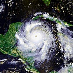
Hurricane Dean was the strongest tropical cyclone of the 2007 Atlantic hurricane season. A Cape Verde-type hurricane that formed on August 13, 2007, Dean took a west-northwest path from the eastern Atlantic Ocean through the Saint Lucia Channel and into the Caribbean. It strengthened into a major hurricane, reaching Category 5 status on the Saffir–Simpson hurricane scale before passing just south of Jamaica on August 20. The storm made landfall on the Yucatán Peninsula on August 21 as a powerful Category 5 storm. It crossed the peninsula and emerged into the Bay of Campeche as a weaker storm, but still at hurricane strength. It intensified briefly before making a second landfall near Tecolutla, Mexico, on August 22. Dean drifted northwest, weakening into a remnant low which dissipated over the southwestern United States.
The hurricane's intense winds, waves, rains and storm surge were responsible for at least 45 deaths across ten countries, and caused estimated damages ofUS$1.5 billion. Dean's path through the Caribbean devastated crops, particularly those of Martinique and Jamaica. Upon reaching Mexico, Hurricane Dean was a Category 5 storm—the third-most intense Atlantic hurricane at landfall in recorded history. However, it missed major population centers, so it caused no deaths and less damage than its passage through the Caribbean islands as a Category 2 storm.
Dean was the first hurricane to make landfall in the Atlantic basin at Category 5 intensity in 15 years; the last storm to do so was Hurricane Andrew on August 24, 1992. Dean's landfall was far less damaging than Andrew's, but its long swath of damage earned its name retirement from the World Meteorological Organization's Atlantic hurricane naming lists.
Recently selected articles: Weather forecasting, Climate of India, More...
Selected article 23
Portal:Weather/Selected article/23
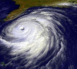
Hurricane Floyd was the sixth named storm, fourth hurricane, and third major hurricane in the 1999 Atlantic hurricane season. Floyd triggered the third largest evacuation in US history (behind Hurricane Gustav and Hurricane Rita, respectively) when 2.6 million coastal residents of five states including Florida were ordered from their homes as Hurricane Floyd approached. The Cape Verde-type hurricane formed off the coast of Africa and lasted from September 7 to September 19, peaking in strength as a very strong Category 4 hurricane—just short of the highest possible rating—on the Saffir-Simpson Hurricane Scale. It was among the largest Atlantic hurricanes of its strength ever recorded.
Floyd struck The Bahamas at peak strength, causing heavy damage. It then paralleled the East Coast of the United States, causing massive evacuations and costly preparations. The storm weakened significantly, however, before making landfall in North Carolina as a Category 2 hurricane, and caused further damage as it traveled up the Mid-Atlantic region and into New England.
The hurricane produced torrential rainfall in eastern North Carolina, adding more rain to an area hit by Hurricane Dennis just weeks earlier. The rains caused widespread flooding over a period of several weeks; nearly every river basin in the eastern part of the state exceeded 500-year flood levels. In total, Floyd was responsible for 57 fatalities and $4.5 billion ($6.0 billion in 2008 U.S. dollars) in damage, mostly in North Carolina.
Recently selected articles: Hurricane Dean, Weather forecasting, Climate of India, More...
Selected article 24
Portal:Weather/Selected article/24
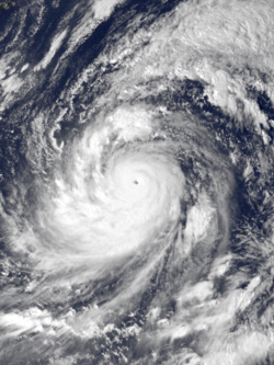
Typhoon Tip was the largest and most intense tropical cyclone on record. The nineteenth tropical storm and twelfth typhoon of the 1979 Pacific typhoon season, Tip developed out of a disturbance in the monsoon trough on October 4 near Pohnpei. Initially, a tropical storm to its northwest hindered the development and motion of Tip, though after it tracked further north Tip was able to intensify. After passing Guam, it rapidly intensified and reached peak winds of 305 km/h (190 mph) and a worldwide record low sea-level pressure of 870 mbar (hPa, 25.69 inHg) on October 12. At its peak strength, it was also the largest tropical cyclone on record with a diameter of 2,220 km (1,380 mi). It slowly weakened as it continued west-northwestward, and later turned to the northeast under the influence of an approaching trough. Tip made landfall on southern Japan on October 19, and became an extratropical cyclone shortly thereafter.
U.S. Air Force Reconnaissance flew into the typhoon for 60 missions, making Tip one of the most closely observed tropical cyclones. Rainfall from the typhoon breached a flood-retaining wall at a United States Marine Corps training camp in the Kanagawa Prefecture of Japan, leading to a fire which injured 68 and killed 13 Marines. Elsewhere in the country, the typhoon led to widespread flooding and 42 deaths, and offshore shipwrecks left 44 killed or missing.
Recently selected articles: Hurricane Floyd, Hurricane Dean, Weather forecasting, More...
Selected article 25
Portal:Weather/Selected article/25

The Evansville Tornado of November 2005 was a powerful tornado that formed early in the morning of November 6, 2005, outside of Evansville, a city in Southwestern Indiana on the Ohio River. It was the first of several significant tornado events in the month of November 2005. The tornado resulted in 25 confirmed fatalities across the region, making it by far the deadliest and most destructive tornado in the United States in 2005, and it was also the deadliest single tornado in the US since 36 died in Oklahoma on May 3, 1999. Significant tornadoes were also reported in western Kentucky on the same day, but none were as damaging or deadly as the Evansville storm.
Recently selected articles: Typhoon Tip, Hurricane Floyd, Hurricane Dean, More...
Selected article 26
Portal:Weather/Selected article/26
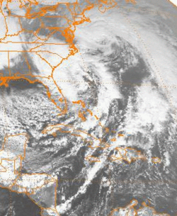
The Christmas 1994 nor'easter was an intense cyclone along the East Coast of the United States and Atlantic Canada. It developed from an area of low pressure in the southeast Gulf of Mexico near the Florida Keys, and moved across the state of Florida. As it entered the warm waters of the Gulf Stream in the Atlantic Ocean, it began to rapidly intensify, exhibiting traits of a tropical system, including the formation of an eye. It attained a pressure of 970 millibars on December 23 and 24, and after moving northward, it came ashore near New York City on Christmas Eve. Due to the uncertain nature of the storm, the National Hurricane Center (NHC) did not classify it as a tropical cyclone.
Heavy rain from the developing storm contributed to significant flooding in South Carolina. Much of the rest of the East Coast was affected by high winds, coastal flooding, and beach erosion. New York State and New England bore the brunt of the storm; damage was extensive on Long Island, and in Connecticut, 130,000 households lost electric power during the storm. Widespread damage and power outages also occurred throughout Rhode Island and Massachusetts, where the storm generated 30-foot (9.1 m) waves along the coast. Due to the warm weather pattern that contributed to the storm's development, precipitation was limited to rain. Two people were killed, and damage amounted to at least $21 million dollars.
Recently selected articles: Evansville Tornado of November 2005,Typhoon Tip, Hurricane Floyd, More...
Selected article 27
Portal:Weather/Selected article/27
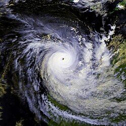
Severe Tropical Cyclone Orson was the fourth most intense cyclone ever recorded in the Australian region. Forming out of a tropical low on 17 April 1989, Orson gradually intensified as it tracked towards the west. After attaining Category 5 intensity on 20 April, the storm began to track southward and accelerated. The following day, the cyclone reached its peak intensity with winds of 250 km/h (155 mph 10-minute sustained) and a barometric pressure of 904 hPa (mbar). Orson maintained this intensity for nearly two days before making landfall near Dampier. The cyclone rapidly weakened after landfall as it accelerated to the southeast. After moving into the Great Australian Bight on 24 April, the storm dissipated.
Despite Orson's extreme intensity, damage was relatively minimal as it struck a sparsely populated region of Western Australia. Five people were killed offshore and damages amounted to A$20 million (US$16.8 million). The storm damaged a new gas platform that explored a possible oil field, believed to contain nearly 200 million gallons of oil. The damage delayed the project for nearly two weeks. The most severe impacts took place in Pannawonica, where 70 homes were damaged. Following the storm, clean up costs reached A$5 million (US$4.1 million). Due to the severity of the storm, the name Orson was retired in 1990 and later replaced by Olga.
Recently selected articles: Christmas 1994 nor'easter, Evansville tornado of November 2005, Typhoon Tip, More...
Selected article 28
Portal:Weather/Selected article/28

A tornado is a violent, dangerous, rotating column of air which is in contact with both the surface of the earth and a cumulonimbus cloud or, in rare cases, the base of a cumulus cloud. The most intense of all atmospheric phenomena, tornadoes come in many shapes and sizes but are typically in the form of a visible condensation funnel, whose narrow end touches the earth and is often encircled by a cloud of debris and dust. Most tornadoes have wind speeds between 40 mph (64 km/h) and 110 mph (177 km/h), are approximately 250 feet (75 m) across, and travel a few miles (several kilometers) before dissipating. The most extreme can attain wind speeds of more than 300 mph (480 km/h), stretch more than a mile (1.6 km) across, and stay on the ground for dozens of miles (more than 100 km).
Various types of tornadoes include the landspout, multiple-vortex tornado, and waterspout. Waterspouts have similar characteristics to tornadoes, characterized by a spiraling funnel-shaped wind current that form over bodies of water, connecting to large cumulus and thunderstorm clouds. These spiraling columns of air frequently develop in tropical areas close to the equator, and are less common at high latitudes. Other tornado-like phenomena which exist in nature include the gustnado, dust devil, fire whirls, and steam devil.
Tornadoes have been observed on every continent except Antarctica. The vast majority of tornadoes in the world occur in the Tornado Alley region of the United States, although they frequently occur in a large portion in North America. They also occasionally occur in south-central and eastern Asia, the Philippines, east-central South America, Southern Africa, northwestern and southeast Europe, western and southeastern Australia, and New Zealand. Tornadoes can be detected before or as they occur through the use of pulse-Doppler radar by recognizing patterns in velocity and reflectivity data, such as hook echoes, as well as by the efforts of storm spotters.
There are several different scales for rating the strength of tornadoes. The Fujita scale rates tornadoes by damage caused, and has been replaced in some countries by the updated Enhanced Fujita scale. An F0 or EF0 tornado, the weakest category, damages trees but not substantial structures. An F5 or EF5 tornado, the strongest category, rips buildings off their foundations and can deform large skyscrapers. The similar TORRO scale ranges from a T0 for extremely weak tornadoes to T11 for the most powerful known tornadoes. Doppler radar data, photogrammetry, and ground swirl patterns (cycloidal marks) may also be analyzed to determine intensity and assign a rating.
Recently selected articles: April, Christmas 1994 nor'easter, Evansville Tornado of November 2005, More...
Selected article 29
Portal:Weather/Selected article/29
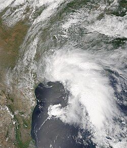
Tropical Storm Allison was a tropical storm that devastated southeast Texas in June of the 2001 Atlantic hurricane season. The first storm of the season, Allison lasted unusually long for a June storm, remaining tropical or subtropical for 15 days. The storm developed from a tropical wave in the northern Gulf of Mexico on June 4, 2001, and struck the upper Texas coast shortly thereafter. It drifted northward through the state, turned back to the south, and re-entered the Gulf of Mexico. The storm continued to the east-northeast, made landfall on Louisiana, then moved across the southeast United States and Mid-Atlantic. Allison was the first storm since Tropical Storm Frances in 1998 to strike the northern Texas coastline.
The storm dropped heavy rainfall along its path, peaking at over 40 inches (1,000 mm) in Texas. The worst flooding occurred in Houston, where most of Allison's damage occurred: 30,000 became homeless after the storm flooded over 70,000 houses and destroyed 2,744 homes. Downtown Houston was inundated with flooding, causing severe damage to hospitals and businesses. Twenty-three people died in Texas. Throughout its entire path, Allison caused $5.5 billion ($6.7 billion 2008 USD) in damage and 41 deaths. Aside from Texas, the places worst hit were Louisiana and southeastern Pennsylvania.
Following the storm, President George W. Bush designated 75 counties along Allison's path as disaster areas (the first time he had to do so), which enabled the citizens affected to apply for aid. Allison is the only tropical storm to have its name retired without ever having reached hurricane strength.
Recently selected articles: April, May, Christmas 1994 nor'easter, More...
Selected article 30
Portal:Weather/Selected article/30

The atmosphere of Jupiter is the largest planetary atmosphere in the Solar System. It is mostly made of molecular hydrogen and helium; other chemical compounds are present only in small amounts and include methane, ammonia, hydrogen sulfide and water. Although water is thought to reside deep in the atmosphere, its directly measured concentration is very low. The nitrogen, sulfur, and noble gas abundances in Jupiter's atmosphere exceed solar values by a factor of about three.
The atmosphere of Jupiter lacks a clear lower boundary and gradually transitions into the liquid interior of the planet. From lowest to highest, the atmospheric layers are the troposphere, stratosphere, thermosphere and exosphere. Each layer has characteristic temperature gradients. The lowest layer, the troposphere, has a complicated system of clouds and hazes, comprised of layers of ammonia, ammonium hydrosulfide and water. The upper ammonia clouds visible at Jupiter's surface are organized in a dozen zonal bands parallel to the equator and are bounded by powerful zonal atmospheric flows (winds) known as jets. The bands alternate in color: the dark bands are called belts, while light ones are called zones. Zones, which are colder than belts, correspond to upwellings, while belts mark descending gas. The zones' lighter color is believed to result from ammonia ice; what gives the belts their darker colors is uncertain. The origins of the banded structure and jets are not well understood, though a "shallow model" and a "deep model" exist.
The Jovian atmosphere shows a wide range of active phenomena, including band instabilities, vortices (cyclones and anticyclones), storms and lightning. The vortices reveal themselves as large red, white or brown spots (ovals). The largest two spots are the Great Red Spot (GRS) and Oval BA, which is also red. These two and most of the other large spots are anticyclonic. Smaller anticyclones tend to be white. Vortices are thought to be relatively shallow structures with depths not exceeding several hundred kilometers. Located in the southern hemisphere, the GRS is the largest known vortex in the Solar System. It could engulf two or three Earths and has existed for at least three hundred years.
Jupiter has powerful storms, often accompanied by lightning strikes. The storms are a result of moist convection in the atmosphere connected to the evaporation and condensation of water. They are sites of strong upward motion of the air, which leads to the formation of bright and dense clouds. The storms form mainly in belt regions. The lightning strikes on Jupiter are hundreds of times more powerful than those seen on Earth, and are assumed to be associated with the water clouds.
Recently selected articles: Tropical Storm Allison, Tornado, Cyclone Orson, More...
Selected article 31
Portal:Weather/Selected article/31

Wind is the flow of gases on a large scale. On the surface of the Earth, wind consists of the bulk movement of air. In outer space, solar wind is the movement of gases or charged particles from the Sun through space, while planetary wind is the outgassing of light chemical elements from a planet's atmosphere into space. Winds are commonly classified by their spatial scale, their speed, the types of forces that cause them, the regions in which they occur, and their effect. The strongest observed winds on a planet in the Solar System occur on Neptune and Saturn. Winds have various aspects: velocity (wind speed); the density of the gas involved; energy content or wind energy. Wind is also an important means of transportation for seeds and small birds; with time things can travel thousands of miles in the wind.
In meteorology, winds are often referred to according to their strength, and the direction from which the wind is blowing. Short bursts of high-speed wind are termed gusts. Strong winds of intermediate duration (around one minute) are termed squalls. Long-duration winds have various names associated with their average strength, such as breeze, gale, storm, and hurricane. Wind occurs on a range of scales, from thunderstorm flows lasting tens of minutes, to local breezes generated by heating of land surfaces and lasting a few hours, to global winds resulting from the difference in absorption of solar energy between the climate zones on Earth. The two main causes of large-scale atmospheric circulation are the differential heating between the equator and the poles, and the rotation of the planet (Coriolis effect). Within the tropics, thermal low circulations over terrain and high plateaus can drive monsoon circulations. In coastal areas the sea breeze/land breeze cycle can define local winds; in areas that have variable terrain, mountain and valley breezes can dominate local winds.
In human civilization, the concept of wind has been explored in mythology, influenced the events of history, expanded the range of transport and warfare, and provided a power source for mechanical work, electricity, and recreation. Wind powers the voyages of sailing ships across Earth's oceans. Hot air balloons use the wind to take short trips, and powered flight uses it to increase lift and reduce fuel consumption. Areas of wind shear caused by various weather phenomena can lead to dangerous situations for aircraft. When winds become strong, trees and human-made structures are damaged or destroyed.
Winds can shape landforms, via a variety of aeolian processes such as the formation of fertile soils, such as loess, and by erosion. Dust from large deserts can be moved great distances from its source region by the prevailing winds; winds that are accelerated by rough topography and associated with dust outbreaks have been assigned regional names in various parts of the world because of their significant effects on those regions. Wind also affects the spread of wildfires. Winds can disperse seeds from various plants, enabling the survival and dispersal of those plant species, as well as flying insect populations. When combined with cold temperatures, wind has a negative impact on livestock. Wind affects animals' food stores, as well as their hunting and defensive strategies.
Previously selected articles: Atmosphere of Jupiter, Tropical Storm Allison, Tornado, More...
Selected article 32
Portal:Weather/Selected article/32

Cirrus (cloud classification symbol: Ci) is a genus of high cloud made of ice crystals. Cirrus clouds typically appear delicate and wispy with white strands. In the Earth's atmosphere, cirrus are usually formed when warm, dry air rises, causing water vapor deposition onto mineral dust and metallic particles at high altitudes. Globally, they form anywhere between 4,000 and 20,000 meters (13,000 and 66,000 feet) above sea level, with the higher elevations usually in the tropics and the lower elevations in more polar regions.
Cirrus clouds can form from the tops of thunderstorms and tropical cyclones and sometimes predict the arrival of rain or storms. Although they are a sign that rain and maybe storms are on the way, cirrus themselves drop no more than falling streaks of ice crystals. These crystals dissipate, melt, and evaporate as they fall through warmer and drier air and never reach ground. Cirrus clouds warm the earth, potentially contributing to climate change. A warming earth will likely produce more cirrus clouds, potentially resulting in a self-reinforcing loop.
Optical phenomena, such as sun dogs and halos, can be produced by light interacting with ice crystals in cirrus clouds. There are two other high-level cirrus-like clouds called cirrostratus and cirrocumulus. Cirrostratus looks like a sheet of cloud, whereas cirrocumulus looks like a pattern of small cloud tufts. Unlike cirrus and cirrostratus, cirrocumulus clouds contain droplets of supercooled (below freezing point) water.
Cirrus clouds form in the atmospheres of Mars, Jupiter, Saturn, Uranus, and Neptune; and on Titan, one of Saturn's larger moons. Some of these extraterrestrial cirrus clouds are made of ammonia or methane, much like water ice in cirrus on Earth. Some interstellar clouds, made of grains of dust smaller than a thousandth of a millimeter, are also called cirrus. (Full article...)
