Peep Hill, South Australia
| Peep Hill South Australia | |||||||||||||||
|---|---|---|---|---|---|---|---|---|---|---|---|---|---|---|---|
| Coordinates | 34°9′S 139°9′E / 34.150°S 139.150°E | ||||||||||||||
| Population | 22 (SAL 2021)[1] | ||||||||||||||
| Postcode(s) | 5374[2] | ||||||||||||||
| Elevation | 283 m (928 ft) | ||||||||||||||
| LGA(s) | Regional Council of Goyder | ||||||||||||||
| State electorate(s) | Stuart[2] | ||||||||||||||
| Federal division(s) | Grey[2] | ||||||||||||||
| |||||||||||||||
| Footnotes | Coordinates[3] Elevation[4] | ||||||||||||||
Peep Hill is a rural locality in the Mid North region of South Australia, situated 120km north-east of Adelaide in the Regional Council of Goyder.[2] It was established in August 2000, when boundaries were formalised for the "long established local name".[3] As of 2021, Peep Hill has a population of 22 residents.[5]
Etymology
[edit]Peep Hill is reported to be named for "a round hill in the last range towards the east".[6]
History
[edit]Peep Hill is located on the traditional lands of the Ngadjuri people.[7] The Ngadjuri have been largely overlooked in the histories of colonisation and the subsequent dispossession from their traditional lands.
In 1876, farmer Johann Gottlieb Dohnt was recorded as being one of the first European settlers at Peep Hill.[8] Two years later, in 1878, Peep Hill was described as "no township, but simply a small settlement."[9]
The Peep Hill School, originally named the Deep Creek School, was established in 1883. It closed down in 1939 due to small student numbers. The school building was demolished in 1950 and, by 1986, it was noted to be a pile of rubble.[10][11]

A Lutheran congregation was officially formed in Peep Hill in 1888, although services had been conducted there since 1880. Initially, the congregation worshipped in the school until St Michael's Lutheran Church was opened in 1890.[12] The church underwent renovations in 1936 and transitioned from the Point Pass Parish to the Eudunda Parish in 1966.[10] The church continues in operation, and is now part of the Eudunda Robertstown Lutheran Parish.[13]

Peep Hill Post Office opened on 1 July 1883 and closed on 1 November 1930.[14] The town formerly had a railway siding on the Morgan line, the Deep Creek station.[4]
Demographics
[edit]As of 2021, Peep Hill is a small community with a total population of 22 people. The majority of the population is male, accounting for 64.3%, while females make up 35.7% of the population. The median age of the residents is 44 years. The community has a total of 9 private dwellings, with an average of 2.6 people per household. On average, each dwelling in Peep Hill has 4.3 motor vehicles. The median weekly household income is $1,374, and the median monthly mortgage repayments are $999.[5]
Flora
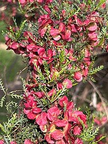
[edit]Dodonaea subglandulifera, also known as Peep Hill hop bush, is a species of plant in the Sapindaceae family. It is native to south-eastern South Australia. Peep Hill hop bush is listed as nationally endangered, with an estimated 45,000 to 50,000 plants remaining.[15]

References
[edit]- ^ Australian Bureau of Statistics (28 June 2022). "Peep Hill (suburb and locality)". Australian Census 2021 QuickStats. Retrieved 28 June 2022.
- ^ a b c d "Search result(s) for Peep Hill, 5374". Location SA Map Viewer. Government of South Australia. Retrieved 14 December 2016.
- ^ a b "Search result(s) for Peep Hill, 5374". Property Location Browser. Government of South Australia. Archived from the original on 12 October 2016. Retrieved 26 November 2016.
- ^ a b "Search result(s) for Deep Creek Railway Station". Location SA Map Viewer. Government of South Australia. Retrieved 14 December 2016.
- ^ a b "2021 Peep Hill, Census All persons QuickStats | Australian Bureau of Statistics". www.abs.gov.au. Retrieved 26 June 2023.
- ^ Dreckow, Betty (1986). Hills, Valley and Plains: History of the Eudunda District. p. 7.
- ^ Studies, Australian Institute of Aboriginal and Torres Strait Islander (10 November 2022). "Map of Indigenous Australia". aiatsis.gov.au. Retrieved 26 June 2023.
- ^ "MR. J. G. DOHNT". Chronicle. 26 January 1929. Retrieved 27 June 2023.
- ^ "SCHOOL NEAR EUDUNDA". South Australian Chronicle and Weekly Mail. 21 December 1878. Retrieved 27 June 2023.
- ^ a b Dreckow, Betty (1986). Hills, Valley and Plains: History of the Eudunda District. p. 388.
- ^ "Peep Hill". Flinders Ranges Research. Retrieved 24 December 2016.
- ^ "KAPUNDA LOCAL BOARD OF ADVICE". Kapunda Herald. 11 May 1883. Retrieved 27 June 2023.
- ^ "Eudunda Robertstown Lutheran Parish". 6 February 2017. Retrieved 11 February 2017.
- ^ "Peep Hill". Post Office Reference. Premier Postal. Retrieved 24 December 2016.
- ^ "Native plant - Peep Hill hop-bush - Department of Environment, Water…". Landscape South Australia - Murraylands and Riverland. Retrieved 26 June 2023.

