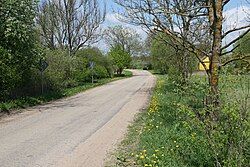
Paąžuolė (Varėna)
You can help expand this article with text translated from the corresponding article in Lithuanian. (October 2018) Click [show] for important translation instructions.
|
Paąžuolė | |
|---|---|
Village | |
 | |
| Coordinates: 54°04′01″N 24°45′40″E / 54.06694°N 24.76111°E | |
| Country | |
| County | |
| Municipality | Varėna |
| Eldership | Kaniavos (Kaniava) |
| Population (2011 Census)[1] | |
• Total | 13 |
| Time zone | UTC+2 (EET) |
| • Summer (DST) | UTC+3 (EEST) |
Paąžuolė is a village in Kaniava eldership, Varėna district municipality, Alytus County, southeastern Lithuania. According to the 2001 census, the village had a population of 25 people.[2] At the 2011 census, the population was 13.[1]
The village was likely established at the end of the 18th century after the massive forest cuts.
Between World War I and World War II, Rytas Elementary School was situated in the village.
Etymology
[edit]The name Paąžuolė comes from the word Lithuanian: ąžuolas ('oak tree') and means 'a place under/by oaks'. The village is mentioned as Polish: Poddębie, Poddębe, Russian: Поддембе in the earlier sources (with the same meaning, i. e. Polish: dęby, dębno 'oaks, oak grove'), so it isn't clear Lithuanian or Slavic name is earlier.[3]
References
[edit]- ^ a b "Population by locality". 2011 Population and Housing Census. Statistics Lithuania. Archived from the original (XLS) on 22 September 2013. Retrieved 10 September 2013.
{{cite web}}: External link in|work= - ^ "Lithuanian Population and Housing Census 2001: Alytaus County" (PDF) (in Lithuanian). Statistikos Departamentas (Lithuania). Archived from the original (PDF) on 22 September 2013. Retrieved 5 May 2010.
- ^ Šimkus, Šarūnas (2023). Varėnos krašto vietovardžių etimologinis žodynas (in Lithuanian). Vilnius: Liutauras Leščinskas. p. 45. ISBN 978-609-447-388-3.


