Pölstal
Appearance
Pölstal | |
|---|---|
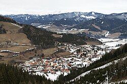
 View of Oberzeiring (part of Pölstal) | |
| Coordinates: 47°17′00″N 14°29′00″E / 47.28333°N 14.48333°E | |
| Country | Austria |
| State | Styria |
| District | Murtal |
| Government | |
| • Mayor | Alois Mayer (ÖVP) |
| Area | |
• Total | 270.65 km2 (104.50 sq mi) |
| Elevation | 915 m (3,002 ft) |
| Population (2018-01-01)[2] | |
• Total | 2,670 |
| • Density | 9.9/km2 (26/sq mi) |
| Time zone | UTC+1 (CET) |
| • Summer (DST) | UTC+2 (CEST) |
| Postal code | 8762, 8763, 8765 |
| Website | www.poelstal.gv.at |
Pölstal is a market town since 2015 in the Murtal District of Styria, Austria.
The municipality, Pölstal, was created as part of the Styria municipal structural reform,[3] at the end of 2014, by merging the former towns Oberzeiring, Bretstein, Sankt Johann am Tauern and Sankt Oswald-Möderbrugg.[4]
Geography
[edit]Municipality arrangement
[edit]The municipality territory includes the following nine sections (populations as of January 2015[5]):
- Bretstein (298)
- Gföllgraben (55)
- Möderbrugg (670)
- Oberzeiring (629)
- Sankt Johann am Tauern Schattseite (115)
- Sankt Johann am Tauern Sonnseite (352)
- Sankt Oswald (477)
- Zeiringgraben (43)
- Zugtal (105)
The municipality consists of the seven Katastralgemeinden Bretstein, Möderbrugg, Oberzeiring, St. Johann Schattseite, St. Johann Sonnseite and St. Oswald.
Tourism
[edit]The municipality formed, together with Pusterwald and Pöls-Oberkurzheim, the tourism agency "Region Pölstal". The base is in the town Pölstal.[6]
Culture and sights
[edit]This section is empty. You can help by adding to it. (August 2017) |
References
[edit]- ^ "Dauersiedlungsraum der Gemeinden Politischen Bezirke und Bundesländer - Gebietsstand 1.1.2018". Statistics Austria. Retrieved 10 March 2019.
- ^ "Einwohnerzahl 1.1.2018 nach Gemeinden mit Status, Gebietsstand 1.1.2018". Statistics Austria. Retrieved 9 March 2019.
- ^ Steiermärkische Gemeindestrukturreform.
- ^ § 3 Abs. 8 Z 2 des Gesetzes vom 17. Dezember 2013 über die Neugliederung der Gemeinden des Landes Steiermark (Steiermärkisches Gemeindestrukturreformgesetz – StGsrG). Landesgesetzblatt für die Steiermark vom 2. April 2014. Nr. 31, Jahrgang 2014. ZDB-ID 705127-x. p. 3.
- ^ Statistik Austria, Bevölkerung am 1.1.2015 nach Ortschaften
- ^ Grazer Zeitung, "Amtsblatt für die Steiermark". 30 December 2014, 210. Jahrgang, 52. Stück. Nr. 316. ZDB-ID 1291268-2 p. 628–629.
External links
[edit]Wikimedia Commons has media related to Pölstal.

