Oiron
Appearance
Oiron | |
|---|---|
Part of Plaine-et-Vallées | |
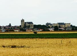
 A general view of Oiron | |
| Coordinates: 46°57′07″N 0°04′49″W / 46.9519°N 0.0803°W | |
| Country | France |
| Region | Nouvelle-Aquitaine |
| Department | Deux-Sèvres |
| Arrondissement | Bressuire |
| Canton | Le Val de Thouet |
| Commune | Plaine-et-Vallées |
Area 1 | 36.75 km2 (14.19 sq mi) |
| Population (2019)[1] | 897 |
| • Density | 24/km2 (63/sq mi) |
| Time zone | UTC+01:00 (CET) |
| • Summer (DST) | UTC+02:00 (CEST) |
| Postal code | 79100 |
| Elevation | 47–133 m (154–436 ft) (avg. 88 m or 289 ft) |
| 1 French Land Register data, which excludes lakes, ponds, glaciers > 1 km2 (0.386 sq mi or 247 acres) and river estuaries. | |
Oiron (French pronunciation: [waʁɔ̃]) is a former commune in the Deux-Sèvres department in western France. In January 1973 it absorbed the former communes Bilazais, Brie and Noizé.[2] On 1 January 2019, it was merged into the new commune Plaine-et-Vallées.[3]
The Château d'Oiron is located there.
See also
[edit]References
[edit]- ^ Téléchargement du fichier d'ensemble des populations légales en 2019, INSEE
- ^ Modifications aux circonscriptions administratives territoriales (fusion de communes), Journal officiel de la République française n° 0009, 11 January 1973, p. 502.
- ^ Arrêté préfectoral 7 November 2018 (in French)
External links
[edit]Wikimedia Commons has media related to Oiron.


