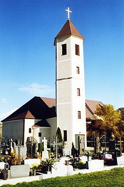
Obritzberg-Rust
Appearance
Obritzberg-Rust | |
|---|---|
 Obritzberg parish church | |
| Coordinates: 48°17′00″N 15°36′00″E / 48.28333°N 15.60000°E | |
| Country | Austria |
| State | Lower Austria |
| District | Sankt Pölten-Land |
| Government | |
| • Mayor | Gerhard Wendl (ÖVP) |
| Area | |
• Total | 41.48 km2 (16.02 sq mi) |
| Elevation | 366 m (1,201 ft) |
| Population (2018-01-01)[2] | |
• Total | 2,342 |
| • Density | 56/km2 (150/sq mi) |
| Time zone | UTC+1 (CET) |
| • Summer (DST) | UTC+2 (CEST) |
| Postal code | 3123 |
| Area code | 02742, 02782, 02786 |
| Vehicle registration | PL |
| Website | www |
This article includes a list of general references, but it lacks sufficient corresponding inline citations. (April 2023) |
Obritzberg-Rust is a municipality in the district of Sankt Pölten-Land in Lower Austria, Austria.
The municipality is divided into 19 cadastral communities. These are Diendorf, Doppel (with the localities of Doppel, Neustift and Hofstetten), Eitzendorf, Flinsdorf, Fugging, Greiling, Großrust, Grünz, Hain (with the localities of Kleinhain, Angern and Großhain), Heinigstetten, Kleinrust, Landhausen, Obermerking, Obritzberg, Pfaffing, Schweinern (with the localities of Schweinern and Thallern), Untermerking (with the localities of Untermerking and Mittermerking), Winzing and Zagging.
Population
[edit]| Year | Pop. | ±% |
|---|---|---|
| 1971 | 2,028 | — |
| 1981 | 2,106 | +3.8% |
| 1991 | 2,135 | +1.4% |
| 2001 | 2,268 | +6.2% |
References
[edit]- ^ "Dauersiedlungsraum der Gemeinden Politischen Bezirke und Bundesländer - Gebietsstand 1.1.2018". Statistics Austria. Retrieved 10 March 2019.
- ^ "Einwohnerzahl 1.1.2018 nach Gemeinden mit Status, Gebietsstand 1.1.2018". Statistics Austria. Retrieved 9 March 2019.


