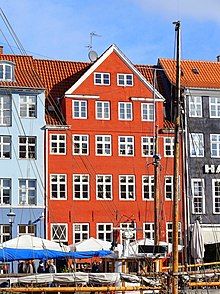
Nyhavn 37
Appearance
| Nyhavn 37 | |
|---|---|
 | |
 | |
| General information | |
| Location | Copenhagen |
| Country | Denmark |
| Coordinates | 55°40′48.5″N 12°35′26.02″E / 55.680139°N 12.5905611°E |
| Completed | 18th century |
Nyhavn 37 is an 18th-century property overlooking the Nyhavn Canal in central Copenhagen, Denmark. The building was listed in the Danish registry of protected buildings and places in 1923.
Architecture
[edit]
The facade is plastered and red painted with white painted windows. It is crowned by a four-bay gabled wall dormer with cornice returns. The main entrance in the bay furthest to the left is topped by a transom window with coloured glass. A two-storey side wing extends from the rear side of the building. The walls on this side of the building are finished with black-painted timber framing and plastered, white-painted infills.[1]
References
[edit]- ^ "Sag: Nyhavn 37". Kulturstyrelsen (in Danish). Retrieved 15 February 2022.
