Nowe Miasteczko
Appearance
Nowe Miasteczko | |
|---|---|
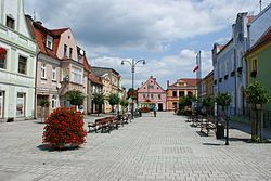
 Rynek (Market Square) | |
| Coordinates: 51°41′N 15°44′E / 51.683°N 15.733°E | |
| Country | |
| Voivodeship | Lubusz |
| County | Nowa Sól |
| Gmina | Nowe Miasteczko |
| Town rights | before 1296 |
| Area | |
• Total | 3.39 km2 (1.31 sq mi) |
| Population (2019-06-30[1]) | |
• Total | 2,756 |
| • Density | 810/km2 (2,100/sq mi) |
| Time zone | UTC+1 (CET) |
| • Summer (DST) | UTC+2 (CEST) |
| Postal code | 67-124 |
| Vehicle registration | FNW |
| Highway | |
| Website | http://www.nowemiasteczko.pl |
Nowe Miasteczko [ˈnɔvɛ mʲasˈtɛt͡ʂkɔ] (German: Neustädtel) is a town in Nowa Sól County, Lubusz Voivodeship, in western Poland, with 2,756 inhabitants (2019).
History
[edit]
The area became part of the emerging Polish state in the 10th century, and following the Poland's fragmentation into smaller provincial duchies, it was part of the duchies of Silesia, Głogów and Żagań.[2] The town was first mentioned in a document of Henry III, Duke of Głogów from 1296, and was granted town rights before that date. In the 18th century, one of two main routes connecting Warsaw and Dresden ran through the town and Kings Augustus II the Strong and Augustus III of Poland traveled that route numerous times.[3]
Demographics
[edit]
|
| |||||||||||||||||||||||||||||||||||||||
| Source: [4][5] | ||||||||||||||||||||||||||||||||||||||||
Notable people
[edit]- Fritz Lubrich (1888–1971), German composer
Twin towns – sister cities
[edit]See twin towns of Gmina Nowe Miasteczko.
References
[edit]- ^ "Population. Size and structure and vital statistics in Poland by territorial division in 2019. As of 30th June". stat.gov.pl. Statistics Poland. 2019-10-15. Retrieved 2020-03-26.
- ^ Orzechowski, Kazimierz; Przybytek, Dariusz; Ptak, Marian (2008). Dolny Śląsk. Podziały terytorialne od X do XX wieku (in Polish). Wrocław. pp. 47–48. ISBN 978-83-923255-5-0.
{{cite book}}: CS1 maint: location missing publisher (link) - ^ "Informacja historyczna". Dresden-Warszawa (in Polish). Retrieved 17 April 2024.
- ^ Dokumentacja Geograficzna (in Polish). Vol. 3/4. Warszawa: Instytut Geografii Polskiej Akademii Nauk. 1967. p. 33.
- ^ Stan i struktura ludności oraz ruch naturalny w przekroju terytorialnym w 2010 r. (PDF) (in Polish). Warszawa: Główny Urząd Statystyczny. 2011. p. 60. Archived from the original (PDF) on 13 November 2011.
Wikimedia Commons has media related to Nowe Miasteczko.


