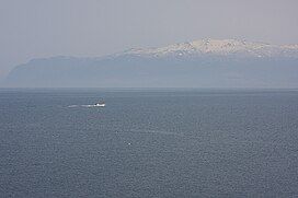
Mount Raiden
Appearance
| Mount Raiden | |
|---|---|
| 雷電山 | |
 Mount Raiden. | |
| Highest point | |
| Elevation | 1,211.3 m (3,974 ft) |
| Prominence | 250 m (820 ft) |
| Parent peak | Mount Mekunnai |
| Listing | List of mountains and hills of Japan by height |
| Coordinates | 42°54′13″N 140°28′10″E / 42.90361°N 140.46944°E |
| Naming | |
| English translation | Thunder and Lightning Mountain |
| Language of name | Japanese |
| Geography | |
| Parent range | Mount Raiden Volcanic Group |
| Topo map(s) | Geographical Survey Institute 25000:1 雷電山 50000:1 島古丹 |
| Geology | |
| Rock age | Quaternary |
| Mountain type | pyroclastic cone |
| Volcanic arc | Northeastern Japan Arc |
Mount Raiden (雷電山, Raiden-yama) is an andesitic volcano[1] in the Mount Raiden Volcanic Group on the border between Iwanai and Rankoshi, Hokkaidō, Japan. Mount Raiden is a pyroclastic cone.[2] The mountain consists of primarily non-alkali, mafic, volcanic rock.[3]
References
[edit]- ^ "RAIDEN-YAMA". Quaternary Volcanoes of Japan. Geological Survey of Japan, AIST. 2006. Archived from the original on December 21, 2012. Retrieved 2008-10-01.
- ^ "Niseko". Global Volcanism Program. Smithsonian Institution. Retrieved 2008-10-01.
- ^ "Hokkaido". Seamless Digital Geological Map of Japan. Geological Survey of Japan, AIST. 2007. Retrieved 2010-10-12.

