Moju Chowdhury Hat
Moju Chowdhury Hat
মজু চৌধুরীর হাট | |
|---|---|
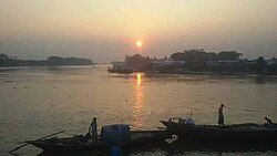
 Moju Chowdhury Hat at Sunrise. | |
| Coordinates: 22°52′26″N 90°47′02″E / 22.87389°N 90.78389°E | |
| Country | |
| Division | Chittagong Division |
| District | Lakshmipur District |
| Upazila | Lakshmipur Sadar Upazila |
| Founded | 1965 |
| Government | |
| • Chairman | Abu Yousuf |
| Area | |
• Total | 68.42 km2 (26.42 sq mi) |
| Population | 100,000 |
| Time zone | UTC+6 (BST) |
| Postal code | |
| Website | charramonimohonup |
Moju Chowdhury Hat (Bengali: মজু চৌধুরীর হাট)[1] is a market village and tourist center in Charramani Mohan Union[2] of Lakshmipur Sadar Upazila in southeastern Bangladesh.[3] According to Banglapedia,[4] the sluice gate on Lakshmipur Khal (canal) is a tourist attraction[5] and a transport hub in southeastern Bangladesh,[6] with over 10,000 travelling passengers per day.[7][8][9][10]
Geography
[edit]The village is on the north bank of Lakshmipur Khal near where it meets the Meghna River.[11][12]
Transport
[edit]National highway[13] N809 is interrupted at Moju Chowdhury Hat by the Meghna River. The village is the southern terminus of the northern segment of the highway, which connects to Laksmipur, about 11 kilometres (6.8 mi) away.[14][15]
There is a ferry ghat (terminal) at Moju Chowdhury Hat. In 2011, The Daily Star reported that unsafe vessels sail the dangerous waters of the Meghna from the village.[16][17][18][19]
See also
[edit]References
[edit]- ^ Moju Chowdhury Hat attractions place. Where birds chirping, At Rahmat khali khal, retrieved 2019-10-19
- ^ চররমনী মোহন ইউনিয়ন. Charramoni Mohon Union (in Bengali). Retrieved 2019-10-18.
- ^ "Upazila Map: Upazila Laxmipur Sadar" (PDF). Local Government Engineering Department. Retrieved 1 August 2017.
- ^ Fenollosa, Ernest Francisco. (2010). Epochs of chinese & japanese art, an outline history of east asiatic design. Nabu Press. ISBN 978-1176605213. OCLC 944410673.
- ^ Mahmud, Nazimuddin (2012). "Lakhsmipur Sadar Upazila". In Sirajul Islam; Miah, Sajahan; Khanam, Mahfuza; Ahmed, Sabbir (eds.). Banglapedia: the National Encyclopedia of Bangladesh (Online ed.). Dhaka, Bangladesh: Banglapedia Trust, Asiatic Society of Bangladesh. ISBN 984-32-0576-6. OCLC 52727562. OL 30677644M. Retrieved 20 December 2024.
- ^ "Port of Moju Chowdhury Hat". www.industryabout.com. Retrieved 2019-10-19.
- ^ Chowdhury, Mostafiz R.; Tabiei, Ala (January 2006). Air Gun Launch Simulation Modeling and Finite Element Model Sensitivity Analysis (Report). Army Research Laboratory. doi:10.21236/ada441366. S2CID 55275601.
- ^ Planet, Lonely. "Sea transport in Barisal". Lonely Planet. Retrieved 2019-10-19.
- ^ "Moju Chowdhury Hat – ভ্রমণবন্ধু". Retrieved 2019-10-19.
- ^ "travel". Joel is curious. Retrieved 2019-10-19.
- ^ Oka, Tarō; Mozammel Hoque, Md. (2004). Hydrological and morphological study of the Meghna River : final report of the Japan-Bangladesh Joint Study Project on Floods. AHOPH--a Development Publishing House. OCLC 74498069.
- ^ "How to get from Chittagong to Barisal by boat". Lost With Purpose. 2018-02-24. Retrieved 2019-10-19.
- ^ "The "Barisal Guns"". Notes and Queries. 1940-01-06. doi:10.1093/notesj/178.1.10. ISSN 1471-6941.
- ^ "RHD Road Network, Comilla Zone". Roads and Highways Department. May 2005. Retrieved 1 August 2017.
- ^ "Laxmipur-Bhola ferry to usher in a new era". bdnews24.com. Retrieved 2019-10-19.
- ^ Ghosh, Sushanta (27 May 2011). "Unsafe water transports ply 'danger zone' defying ban". The Daily Star. Archived from the original on 10 March 2016. Retrieved 10 March 2016.
- ^ "Moju Chowdhury Hat, Chittagong (+880 1771-954928)". placesmap.net. Retrieved 2019-10-19.
- ^ "BIWTC Eid special services start from June 13". Dhaka Tribune. 2018-06-05. Retrieved 2019-10-19.
- ^ Jubair, Ahmed (2017-07-28), Raining Cats and Dog!, retrieved 2019-10-19
External links
[edit] Media related to Moju Chowdhury Hat at Wikimedia Commons
 Moju Chowdhury Hat travel guide from Wikivoyage
- Official website of Charramani Mohan Union

