Milton Park, Montreal
Milton Park | |
|---|---|
 Aylmer looking north from the corner with Milton, in August. | |
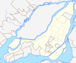
Location of Milton Park in Montreal | |
| Coordinates: 45°30′30″N 73°34′29″W / 45.5083°N 73.5747°W | |
| Country | Canada |
| Province | Quebec |
| City | Montreal |
| Borough | Le Plateau-Mont-Royal |
| Area | |
• Total | 0.52 km2 (0.20 sq mi) |
| • Land | 0.52 km2 (0.20 sq mi) |
| Population | |
• Total | 10,948 |
| • Density | 21,000/km2 (55,000/sq mi) |
| Postal Code | |
| Area code(s) | 514, 438 |
Milton Park (French: Milton-Parc), is a neighbourhood in Montreal, Quebec, Canada. It is named after the neighbourhood's two main streets, Milton Street and Park Avenue. It is situated directly to the east of the McGill University campus in the borough of Plateau-Mont-Royal. The area is roughly bordered by University Street and the university campus to the west, Sherbrooke Street to the south, Pine Avenue to the north, and Park Avenue and the Lower Plateau neighbourhood to the east, though McGill University considers this area to extend as far east as Saint Laurent Boulevard or just short of Saint-Louis Square.
The neighbourhood has many historic townhouses built in the late 19th century, which housed affluent businessmen and their families. The area remained a wealthy enclave throughout the early half of the 20th century. Eventually, many of the affluent residents of the area moved to other boroughs such as Westmount or to the suburbs.
Many McGill students live in this area, which is characterized by a mix of rowhouses and low- to mid-rise apartment buildings. The area has many small businesses catering to the needs of the local McGill community including The Word Bookstore, Café Lola Rosa, and several small convenience stores, as well as many "third place" hangouts.[5]
McGill Ghetto
[edit]Milton Park is commonly known as the McGill Ghetto[citation needed]. While the space is colloquially known as the "Ghetto", the name for the area is used with the original definition of the word "ghetto": an inner-city neighbourhood segregated from the rest of the population.
The McGill Ghetto's population mostly consists of monolingual students[citation needed] coming from other Canadian provinces and English speaking foreign students who tend to stay in the "Ghetto" and avoid mixing with the local francophone population[citation needed]. The word "ghetto" is thus used ironically because this area is not segregated due to economic pressure but because its population chooses to isolate itself from the rest of the city due to cultural and linguistic barriers. There is a movement against this nomenclature because it suggests that the area is completely inhabited by extra-provincial anglophone students, while it is also home to many families, working professionals and long-term residents. Montreal's historic Jewish "Ghetto" coincides in part with the present student Ghetto, meeting at the intersection of Duluth and Saint Laurent.[6]
Development and preservation
[edit]
This section needs expansion. You can help by adding to it. (November 2009) |
In the 1970s, community activists were concerned that the vast La Cité mixed-use complex (consisting of apartments, offices, a mall, and a hotel – now McGill's New Residence) would destroy the neighbourhood's character.[7] A campaign to stop further redevelopment was led by a residents' coalition and the then-newly formed historic preservation group Heritage Montreal.[8]
When McGill University acquired the hotel component of La Cité (at Park and Prince Arthur) and transformed it into an undergraduate student residence (called New Residence Hall), the student population in Milton Park increased by 650 people. La Cité also has a gym Club La Cité with an outdoor pool open year long and crosstraining facilities.[9] In 2009, McGill University purchased a second hotel (Four-Points on Sherbrooke) and transformed it into another student residence for use starting in the 2009–2010 school year.[10]
Exhibitions
[edit]- Milton-Parc: How We Did It, Canadian Centre for Architecture, Montreal (2019)
- Les Jardins des femmes, Peter Gou-hua Fu School of Architecture, Montreal (2019)
See also
[edit]References
[edit]- ^ a b "4620130.00 [Census tract], Quebec and Montréal, TÉ [Census division], Quebec (table)" (Statistics Canada Catalogue no. 98-316-X2016001). Canada 2016 Census. Ottawa: Statistics Canada. 2017-11-29. Retrieved 31 December 2018.
- ^ a b "4620131.00 [Census tract], Quebec and Montréal, TÉ [Census division], Quebec (table)" (Statistics Canada Catalogue no. 98-316-X2016001). Canada 2016 Census. Ottawa: Statistics Canada. 2017-11-29. Retrieved 31 December 2018.
- ^ a b "4620131.00 [Census tract], Quebec and Montréal, TÉ [Census division], Quebec (table)" (Statistics Canada Catalogue no. 98-316-X2016001). Canada 2016 Census. Ottawa: Statistics Canada. 2017-11-29. Retrieved 31 December 2018.
- ^ "Milton-Parc What/Where is Milton Parc?". SSMU External Affairs. Students' Society of McGill University. 18 October 2017. Retrieved 31 December 2018.
- ^ Askren, Hana (2007). "The rhythm of student life". Montreal Magazine.
- ^ Foran, Charles. Mordecai: The Life and Times. Toronto: Random House of Canada, 2010, p. 36.
- ^ Gravenor, Kristian (2008-02-26). "Dashed projects". Coolopolis. Retrieved 2008-02-26.
- ^ John Pierce, Ann Dale, ed. (2000-05-01). Communities, Development, and Sustainability Across Canada. UBC Press. p. 20. ISBN 0-7748-0722-9.
- ^ "Residence Renaissance" Archived 2011-06-11 at the Wayback Machine, "McGill News", Summer 2003. Accessed October 18, 2010.
- ^ "McGill acquires Four Points" Archived 2010-12-18 at the Wayback Machine, "McGill Daily", March 9, 2009. Accessed October 18, 2010.
Further reading
[edit]- Hawley, Joshua, ed. (2019). Villages in cities: community land ownership, cooperative housing, and the Milton Parc story. Montreal: Black Rose Books. ISBN 978-1-55164-687-9.
External links
[edit]- DeWolf, Christopher (2007-09-05). "A window Into Another City". URBANPHOTO. Retrieved 2008-03-28.
- Gravenor, Kristian (1987-07-20). "Studies in Citizen Response: Community Reaction to the Threat of Demolition in Goose Village and Milton Parc, Canadian Urban History, Concordia University". keepandshare.com. Retrieved 2008-09-17.
- Finding aid for the Milton Parc fonds, Canadian Centre for Architecture.
- Illuminated from Within: The Notman Garden series

