Michle
Appearance
This article needs additional citations for verification. (February 2024) |
Michle | |
|---|---|
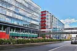
 BB Center, Vyskočilova street | |
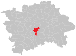
 Location of Michle in Prague | |
| Coordinates: 50°02′55″N 14°27′35″E / 50.04861°N 14.45972°E | |
| Country | Czech Republic |
| Region | Prague |
| District | Prague 4, Prague 10 |
| Area | |
• Total | 5.51 km2 (2.13 sq mi) |
| Population (2021)[1] | |
• Total | 21,402 |
| • Density | 3,900/km2 (10,000/sq mi) |
| Time zone | UTC+1 (CET) |
| • Summer (DST) | UTC+2 (CEST) |
Michle is a district of Prague city, part of Prague 4.[2]
Michle is first mentioned in 1185; it has been part of Prague since 1922.
Demographics
[edit]
|
| |||||||||||||||||||||||||||||||||||||||||||||||||||
| Source: Censuses[3][1] | ||||||||||||||||||||||||||||||||||||||||||||||||||||
References
[edit]- ^ a b "Results of the 2021 Census - Open data". Public Database (in Czech). Czech Statistical Office. 27 March 2021.
- ^ "CZ, Prague: Michle - Peaceful and Industrial District". infoglobe.cz. 20 July 2012. Retrieved 17 February 2024.
- ^ "Historický lexikon obcí České republiky 1869–2011 – Praha" (PDF) (in Czech). Czech Statistical Office. 21 December 2015.
