Metropolis of Lyon
Metropolis of Lyon
Métropole de Lyon (French) | |
|---|---|
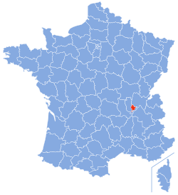
 Location of metropolitan Lyon in metropolitan France | |
 The city (commune) of Lyon (in red) and 58 suburban communes (in blue) make up the metropolitan region. | |
| Coordinates: 45°45′27″N 4°51′14″E / 45.75750°N 4.85389°E | |
| Country | France |
| Region | Auvergne-Rhône-Alpes |
| Prefecture | Lyon |
| Government | |
| • President of the metropolitan council | Bruno Bernard (The Ecologists) |
| Area | |
• Total | 533.68 km2 (206.05 sq mi) |
| Population (2021)[1] | |
• Total | 1,424,069 |
| • Rank | 11th |
| • Density | 2,700/km2 (6,900/sq mi) |
| GDP | |
| • Metro | €98.429 billion (2021) |
| Time zone | UTC+1 (CET) |
| • Summer (DST) | UTC+2 (CEST) |
| Department number | 69M |
| Arrondissements | 1 |
| Cantons | None |
| Communes | 58 |
| Website | www |
The Metropolis of Lyon (French: Métropole de Lyon, pronounced [metʁɔpɔl də ljɔ̃] ⓘ), also known as Grand Lyon ([ɡʁɑ̃ ljɔ̃], "Greater Lyon"), is a French territorial collectivity in the east-central region of Auvergne-Rhône-Alpes. It is a directly-elected metropolitan authority, encompassing both the city of Lyon, and most of its suburbs. It has jurisdiction both as a department, and as a metropolis, which excludes its territory from direct responsibility to the French government department of Rhône. It had a population of 1,424,069 in 2021,[3] 36.7% of whom lived in the city of Lyon proper.
It replaced the Urban Community of Lyon on 1 January 2015, in accordance with the MAPAM law (fr) enacted in January 2014.[4] The first direct metropolitan elections were held in March (1st round) and June (2nd round) 2020, leading to a victory by The Ecologists. The president of the metropolitan council has been Green Party leader Bruno Bernard, since July 2020.
Geography
[edit]The Metropolis of Lyon covers an area of 533.7 km2 (206.1 sq mi).[3] It covers the city of Lyon and its main suburbs. The rivers Rhône and Saône flow through it. It borders the department Rhône to the northwest and southwest, Ain to the northeast, and Isère to the southeast.
Communes
[edit]The Metropolis of Lyon consists of 58 communes.[5] The most populous commune is Lyon. As of 2019, there are 9 communes with more than 30,000 inhabitants:[6]
| Commune | Population (2019) |
|---|---|
| Lyon | 522,969 |
| Villeurbanne | 152,212 |
| Vénissieux | 67,285 |
| Vaulx-en-Velin | 52,795 |
| Saint-Priest | 46,927 |
| Caluire-et-Cuire | 43,294 |
| Bron | 42,244 |
| Meyzieu | 34,640 |
| Rillieux-la-Pape | 30,697 |
See also
[edit]References
[edit]- ^ "Téléchargement du fichier d'ensemble des populations légales en 2021" (in French). The National Institute of Statistics and Economic Studies. 28 December 2023.
- ^ "Gross domestic product (GDP) at current market prices by metropolitan regions". ec.europa.eu.
- ^ a b ,"Intercommunalité-Métropole de Métropole de Lyon (200046977)". INSEE. Retrieved 12 July 2024.
- ^ (in French) Loi n° 2014-58 du 27 janvier 2014 de modernisation de l'action publique territoriale et d'affirmation des métropoles
- ^ Intercommunalité : Métropole de Lyon, INSEE
- ^ Populations légales 2019: 69 Rhône, INSEE
External links
[edit]- Metropolitan Lyon website (in French)
- The Greater Lyon official business website (in English)
- What does the Metropolis of Lyon do? Two minutes to understand everything on YouTube (in French)
