Menghai County
Appearance
(Redirected from Menghai)
Menghai County
勐海县 · ᦵᦙᦲᧂ ᦣᦻ ᦶᦉᧃᧈ | |
|---|---|
 | |
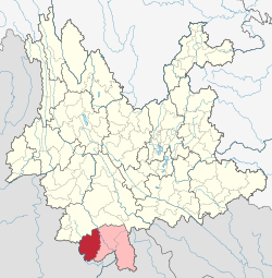
 Location of Menghai County (red) and Xishuangbanna Prefecture (pink) and Yunnan province | |
| Coordinates: 21°58′N 100°28′E / 21.967°N 100.467°E | |
| Country | China |
| Province | Yunnan |
| Autonomous prefecture | Xishuangbanna |
| GB/T 2260 CODE[1] | 532822 |
| County seat | Menghai |
| Area | |
• Total | 5,511 km2 (2,128 sq mi) |
| Population (2020 census)[2] | |
• Total | 353,720 |
| • Density | 64/km2 (170/sq mi) |
| Time zone | UTC+8 (China Standard Time) |
| Postal code | 666200[3] |
| Area code | 0691[3] |
| Climate | Cwa |
| Website | www |
| 1Yunnan Statistics Bureau [1] 2Xishuangbanna Gov. [2] 3Yunnan Portal [3] | |
Menghai County (Chinese: 勐海县; pinyin: Měnghǎi Xiàn; Tai Lue: ᦵᦙᦲᧂ ᦣᦻ ᦶᦉᧃᧈ Meng Haai; Lao: ເມືອງຮາຍ) is a county under the jurisdiction of Xishuangbanna Dai Autonomous Prefecture, in the far south of Yunnan, China, bordering Burma's Shan State to the southwest. Meng is as variation of Mueang.
Ethnic groups
[edit]In and around Menghai County, ethnic Hani subgroups include:[4]
- Jiuwei (鸠为) (Dai exonym: Buli 布里; large population): villages include Nanzhong 南中寨 of Mengjing 勐景,[5] Longnapa 笼那帕寨 of Damenglong 大勐笼, and Baiya 拜牙村 Menggun 勐滚, Menghai County.
- Jizuo (吉坐) (small population): villages include Mengbozhai 勐波寨[6] of Menghan 勐罕村
- Muda (木达) (also locally known as the Nanlin 南林)
Administrative divisions
[edit]Menghai County has 6 towns 2 townships and 3 ethnic townships.[7]
- 6 towns
- 2 townships
- 3 ethnic townships
- Gelanghe Hani (格朗和哈尼族乡)
- Bulangshan Bulang (布朗山布朗族乡)
- Xiding Hani and Bulang (西定哈尼族布朗族乡)
Transport
[edit]- Nearest airport is Xishuangbanna Gasa
- China National Highway 214
- Asian Highway Network AH3 (alternative route) with a border crossing into Myanmar at Daluo. The town on the Myanmar side of the border is Mong La where the road continues to Kengtung
Tea
[edit]Menghai is famous for its Bulang tea, a type of pu-erh grown in the Bulang Mountain area and its environs. Famous plantations include Laoman'e, Xinbanzhang and Laobanzhang.
Climate
[edit]| Climate data for Menghai, elevation 1,223 m (4,012 ft), (1991–2020 normals, extremes 1981–2010) | |||||||||||||
|---|---|---|---|---|---|---|---|---|---|---|---|---|---|
| Month | Jan | Feb | Mar | Apr | May | Jun | Jul | Aug | Sep | Oct | Nov | Dec | Year |
| Record high °C (°F) | 28.5 (83.3) |
31.2 (88.2) |
33.1 (91.6) |
35.0 (95.0) |
35.2 (95.4) |
33.2 (91.8) |
32.1 (89.8) |
32.3 (90.1) |
31.7 (89.1) |
30.6 (87.1) |
29.0 (84.2) |
27.5 (81.5) |
35.2 (95.4) |
| Mean daily maximum °C (°F) | 22.8 (73.0) |
25.1 (77.2) |
28.1 (82.6) |
29.8 (85.6) |
29.2 (84.6) |
28.3 (82.9) |
27.3 (81.1) |
27.5 (81.5) |
27.4 (81.3) |
25.9 (78.6) |
24.0 (75.2) |
21.8 (71.2) |
26.4 (79.6) |
| Daily mean °C (°F) | 14.7 (58.5) |
16.3 (61.3) |
19.4 (66.9) |
22.1 (71.8) |
23.5 (74.3) |
24.1 (75.4) |
23.7 (74.7) |
23.6 (74.5) |
22.9 (73.2) |
21.0 (69.8) |
17.9 (64.2) |
15.0 (59.0) |
20.3 (68.6) |
| Mean daily minimum °C (°F) | 6.7 (44.1) |
7.5 (45.5) |
10.7 (51.3) |
14.5 (58.1) |
17.8 (64.0) |
20.0 (68.0) |
20.1 (68.2) |
19.7 (67.5) |
18.4 (65.1) |
16.2 (61.2) |
11.8 (53.2) |
8.3 (46.9) |
14.3 (57.8) |
| Record low °C (°F) | −1.0 (30.2) |
0.2 (32.4) |
1.2 (34.2) |
5.7 (42.3) |
11.0 (51.8) |
16.0 (60.8) |
16.5 (61.7) |
14.5 (58.1) |
10.8 (51.4) |
7.0 (44.6) |
1.3 (34.3) |
−3.5 (25.7) |
−3.5 (25.7) |
| Average precipitation mm (inches) | 20.7 (0.81) |
11.7 (0.46) |
28.4 (1.12) |
58.1 (2.29) |
149.1 (5.87) |
187.4 (7.38) |
278.8 (10.98) |
268.9 (10.59) |
148.8 (5.86) |
112.5 (4.43) |
50.3 (1.98) |
26.2 (1.03) |
1,340.9 (52.8) |
| Average precipitation days (≥ 0.1 mm) | 4.6 | 3.1 | 4.7 | 10.3 | 17.9 | 23.1 | 26.2 | 25.0 | 19.1 | 15.6 | 8.3 | 6.3 | 164.2 |
| Average relative humidity (%) | 77 | 69 | 64 | 68 | 75 | 82 | 86 | 86 | 86 | 85 | 84 | 83 | 79 |
| Mean monthly sunshine hours | 220.5 | 227.0 | 229.1 | 218.6 | 193.8 | 122.9 | 87.8 | 106.3 | 125.2 | 132.7 | 162.9 | 175.9 | 2,002.7 |
| Percent possible sunshine | 65 | 70 | 61 | 57 | 47 | 30 | 21 | 27 | 34 | 37 | 49 | 53 | 46 |
| Source: China Meteorological Administration[8][9] | |||||||||||||
References
[edit]- ^ "中华人民共和国国家统计局 >> 行政区划代码". Archived from the original on 2009-02-21. Retrieved 2009-01-29.
- ^ "西双版纳州第七次全国人口普查主要数据公报" (in Chinese). Government of Xishuangbanna Prefecture. 2021-05-18.
- ^ a b "Area Code and Postal Code in Yunnan Province". Archived from the original on 2007-11-07. Retrieved 2009-01-30.
- ^ "哈尼族社会历史调查". 中国少数民族社会历史调查资料丛刊》. Beijing: Beijing Minorities Press (民族出版社). 2009. pp. 102–120.
- ^ "勐海县勐海镇景龙村委会". Archived from the original on 2018-06-13. Retrieved 2014-10-11.
- ^ "景洪市勐罕镇勐波村委会勐波村". Archived from the original on 2018-06-13. Retrieved 2014-10-11.
- ^ "国家统计局" (in Chinese). National Bureau of Statistics of the People's Republic of China. Retrieved 2021-12-07.
- ^ 1991-2020 normals "Climate averages from 1991 to 2020". China Meteorological Administration. Archived from the original on 2023-04-17.
- ^ 1981-2010 extremes 中国气象数据网 – WeatherBk Data [China Meteorological Data Network - WeatherBk Data] (in Simplified Chinese). China Meteorological Administration. Retrieved 14 April 2023.
Further reading
[edit]- Jacobs, Andrew. EMBARGO: In once-booming tea region, a bitter reality. International Herald Tribune. (2009-01-09)
External links
[edit]

