Matuail

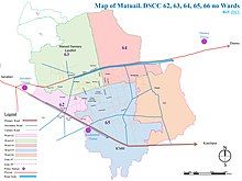
Matuail is located in Dhaka South City Corporation (DSCC), Ward no. 62(part), 63, 64, 65 & 66(part), Dhaka Division, Bangladesh.
History
[edit]Matuail lies within the Dhaka-Narayanganj-Demra Irrigation Project (DND) area. The project, started in 1962 and completed in 1968,[1] was meant to transform the floodplain of three rivers: the Buriganga, Balu, and Shitalakshya, into an agricultural polder protected by embankments against flooding and drained or irrigated by a pumping station.[2]
Unplanned urbanization and industrialization took off within the DND in 1988 after the Dhaka–Chittagong Highway was completed.[1] By 2005, waterlogging had become a perennial problem there, caused by the lack of a sewage system, encroachment on drainage canals, and inadequate pumping facilities.[3]
Matuail became part of Dhaka South City Corporation in 2016 when Dhaka was expanded to include 16 largely rural union parishads mostly to the east.[4] This increased the pace of urban sprawl.[1] Over the years, numerous projects to address the area's chronic drainage problems have been announced, but as of 2023 they remain unresolved.[3][5][6]
Geography
[edit]It is located on the north side of the Dhaka–Chittagong Highway and on the south side of the Dhaka-Sylhet (Old Dhaka-Demra) Highway. Its area is 10.16 square kilometres (3.92 sq mi).[citation needed] The area is about 6 kilometres (3.7 mi) away from Motijheel.
Education
[edit]There are two colleges in Matuail: Matuail Haji Abdul Latib Bhuiyan College, founded in 1994, and Dr. Mahbubur Rahman Mollah College (2009). The former is the only honors level one.
Secondary schools include Shamsul Hoque Khan School and College, founded in 1989, Rafiqul Islam School and College (2014), Matuail Bahumukhi High School (1969), Matuail Adarsha High School (1985), and Matuail Girls High School (2007).
References
[edit]- ^ a b c Rahman, Sadiqur (8 September 2023). "Matuail: A new town without a sewerage system". The Business Standard.
- ^ Rasid, Harun (June 1996). "Impact Assessments from Survey of Floodplain Residents: The Case of the Dhaka-Narayanganj-Demra (DND) Project, Bangladesh". Impact Assessment. 14 (2): 116–118. doi:10.1080/07349165.1996.9725893.
- ^ a b "Govt to undertake Tk 233 crore project for DND area". bdnews24.com. 23 July 2005.
- ^ Bird, Julia; Li, Yue; Rahman, Hussain Zillur; Rama, Martín; Venables, Anthony (2018). Towards great Dhaka: a new urban development paradigm eastward. Washington, DC: World Bank Group. p. 33. ISBN 978-1-4648-1238-5.
- ^ Ullah, Ahamed (7 July 2017). "Illegal structures hinder water flow of DND canal". Daily Sun.
- ^ "Narayanganj's DND area gets waterlogged after heavy rains". The Financial Express. UNB. 2 July 2023.
23°42′44″N 90°27′35″E / 23.71222°N 90.45972°E
