Marivan County
You can help expand this article with text translated from the corresponding article in Persian. (August 2009) Click [show] for important translation instructions.
|
Marivan County
Persian: شهرستان مریوان | |
|---|---|
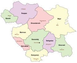
 Location of Marivan County in Kurdistan province (left, yellow) | |
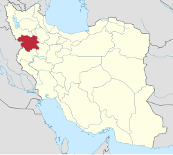
 Location of Kurdistan province in Iran | |
| Coordinates: 35°36′N 46°21′E / 35.600°N 46.350°E[1] | |
| Country | Iran |
| Province | Kurdistan |
| Capital | Marivan |
| Districts | Central, Khav and Mirabad, Sarshiv |
| Population (2016)[2] | |
• Total | 195,263 |
| Time zone | UTC+3:30 (IRST) |
| Marivan County can be found at GEOnet Names Server, at this link, by opening the Advanced Search box, entering "9206644" in the "Unique Feature Id" form, and clicking on "Search Database". | |
Marivan County (Persian: شهرستان مریوان)[a] is in Kurdistan province, Iran. Its capital is the city of Marivan.[3]
History
[edit]Until 1958 the county was known as Marivan District, an administrative division of Sanandaj County. At that time, Kalatrazan District, Sarvabad County, and Sarshiv District were parts of Marivan District.
After the 2006 National Census, the village of Kani Dinar merged with the village of Shahrak-e Hejrat and was elevated to the status of a city.[4] After the 2011 census, the village of Bardeh Rasheh rose to city status as well.[5]
Demographics
[edit]Population
[edit]At the time of the 2006 census, the county's population was 150,926 in 35,498 households.[6] The following census in 2011 counted 168,774 people in 44,258 households.[7] The 2016 census measured the population of the county as 195,263 in 55,603 households. Of these, 151,188 lived in urban centers while 44,075 lived in rural regions; 99,956 were male and 95,307 were female.[2]
Administrative divisions
[edit]Marivan County's population history and administrative structure over three consecutive censuses are shown in the following table.
| Administrative Divisions | 2006[6] | 2011[7] | 2016[2] |
|---|---|---|---|
| Central District | 128,445 | 148,324 | 176,450 |
| Kumasi RD | 4,655 | 3,586 | 2,972 |
| Sarkal RD | 22,745 | 13,086 | 13,937 |
| Zarivar RD | 9,381 | 9,773 | 9,828 |
| Kani Dinar (city) | 11,415 | 13,059 | |
| Marivan (city) | 91,664 | 110,464 | 136,654 |
| Khav and Mirabad District | 11,849 | 11,411 | 10,888 |
| Khav and Mirabad RD | 11,849 | 11,411 | 9,868 |
| Bardeh Rasheh (city) | 1,020 | ||
| Sarshiv District | 10,632 | 9,039 | 7,924 |
| Gol-e Cheydar RD | 4,878 | 4,421 | 3,593 |
| Sarshiv RD | 5,321 | 4,434 | 3,876 |
| Chenareh (city) | 433 | 184 | 455 |
| Total | 150,926 | 168,774 | 195,263 |
| RD = Rural District | |||
Geography
[edit]Marivan County is bordered by Saqqez County to the north, Sanandaj County to the east and southeast, Paveh County to the south, and Iraq to the west and northwest.
See also
[edit]![]() Media related to Marivan County at Wikimedia Commons
Media related to Marivan County at Wikimedia Commons
Notes
[edit]References
[edit]- ^ OpenStreetMap contributors (19 August 2023). "Marivan County" (Map). OpenStreetMap (in Persian). Retrieved 19 August 2023.
- ^ a b c "Census of the Islamic Republic of Iran, 1395 (2016)". AMAR (in Persian). The Statistical Center of Iran. p. 12. Archived from the original (Excel) on 8 May 2022. Retrieved 19 December 2022.
- ^ Habibi, Hassan (21 June 1369). "Approval of the organization and chain of citizenship of the elements and units of the national divisions of Kurdistan province, centered in the city of Sanandaj". Islamic Parliament Research Center of the Islamic Republic of Iran (in Persian). Ministry of Interior, Defense Political Commission of the Government Board. Archived from the original on 23 October 2018. Retrieved 22 January 2024.
- ^ Davoudi, Parviz (31 May 2009). "The government's agreement with three changes in the country divisions of Razavi Khorasan and Kurdistan". Ministry of Interior (in Persian). Ministry of Interior, Cabinet of Ministers. Archived from the original on 4 March 2016. Retrieved 17 August 2023.
- ^ Rahimi, Mohammad Reza (14 January 2013). "Approval letter regarding the transformation of Uraman Takht village, the center of Uraman District of Sarvabad County in Kurdistan province, into a city". Lamtakam (in Persian). Ministry of Interior, Political and Defense Commission. Archived from the original on 22 January 2024. Retrieved 22 January 2024.
- ^ a b "Census of the Islamic Republic of Iran, 1385 (2006)". AMAR (in Persian). The Statistical Center of Iran. p. 12. Archived from the original (Excel) on 20 September 2011. Retrieved 25 September 2022.
- ^ a b "Census of the Islamic Republic of Iran, 1390 (2011)". Syracuse University (in Persian). The Statistical Center of Iran. p. 12. Archived from the original (Excel) on 19 January 2023. Retrieved 19 December 2022.

