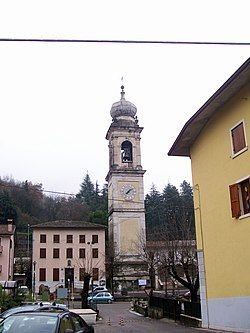
Lugo di Valpantena
Appearance
Lugo di Valpantena | |
|---|---|
 | |
 | |
| Coordinates: 45°30′20″N 10°59′32″E / 45.50556°N 10.99222°E | |
| Country | Italy |
| Region | Veneto |
| Comune | Verona |
Lugo di Valpantena is a village in the province of Verona in Italy. It is a frazione of the comune of Grezzana.[1][2]
Geography
[edit]The village, located in the upper Valpantena, lies approximately 6 kilometers north of Grezzana and 15 kilometers from Verona. It is situated along the provincial road SP14, known as the "Alta Valpantena Road," which connects the valley to the localities of upper Lessinia. Just north of Lugo, the Valpantena splits into three deep ravines: the Vajo della Marciora, the Vajo dei Falconi, and the Vajo dell'Anguilla. Surrounding these ravines are significant peaks such as Corno d'Aquilio, Corno Mozzo, and Monte Tomba.[3]
Main sights
[edit]- The parish church is dedicated to Sant'Apollinare (ninth century)
- The oratory of Corso is dedicated to Saint Paul (1685)
Notable people
[edit]- Eugenio Dal Corso, (1939 – 2024) bishop of Lodi, born in Marne
References
[edit]- ^ Fabio Cavulli e Annalisa Pedrotti, L'insediamento del Neolitico antico di Lugo di Grezzana: la palizzata lìgnea, Preistoria Alpina, 2001, 37, 11-24, ISSN 0393-0157
- ^ Lugo e il modello del Nordest ildibattito.it
- ^ "Il Corno d'Aquilio". speleolessinia.it. 2014-04-27. Archived from the original on 2014-04-27. Retrieved 2024-12-16.
