Lamalou-les-Bains
Appearance
Lamalou-les-Bains | |
|---|---|
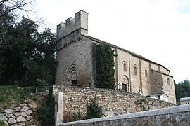
 Saint-Pierre-de-Rhèdes church | |
| Coordinates: 43°35′55″N 3°04′50″E / 43.5986°N 3.0806°E | |
| Country | France |
| Region | Occitania |
| Department | Hérault |
| Arrondissement | Béziers |
| Canton | Clermont-l'Hérault |
| Government | |
| • Mayor (2020–2026) | Guillaume Dalery[1] |
Area 1 | 6.18 km2 (2.39 sq mi) |
| Population (2022)[2] | 2,421 |
| • Density | 390/km2 (1,000/sq mi) |
| Time zone | UTC+01:00 (CET) |
| • Summer (DST) | UTC+02:00 (CEST) |
| INSEE/Postal code | 34126 /34240 |
| Elevation | 175–458 m (574–1,503 ft) (avg. 600 m or 2,000 ft) |
| 1 French Land Register data, which excludes lakes, ponds, glaciers > 1 km2 (0.386 sq mi or 247 acres) and river estuaries. | |
Lamalou-les-Bains (French pronunciation: [lamalu le bɛ̃]; Languedocien: L’Amalon) is a commune in the Hérault département in the Occitanie region in southern France.

Geography
[edit]Lamalou-les-Bains is located 53½ miles west of Montpellier in the Orb valley of the southern Cévennes. The village lies at an altitude of 200 metres and offers commanding views of the rivers, lakes and mountains situated in Haut Languedoc.
Population
[edit]Its inhabitants are called Lamalousiens in French.
| Year | Pop. | ±% p.a. |
|---|---|---|
| 1968 | 2,029 | — |
| 1975 | 2,067 | +0.27% |
| 1982 | 2,202 | +0.91% |
| 1990 | 2,194 | −0.05% |
| 1999 | 2,156 | −0.19% |
| 2007 | 2,256 | +0.57% |
| 2012 | 2,663 | +3.37% |
| 2017 | 2,509 | −1.18% |
| Source: INSEE[3] | ||
Spa
[edit]The waters, which are both hot and cold, are used in cases of rheumatism, sciatica, locomotor ataxia and nervous maladies.
International relations
[edit]Lamalou-les-Bains is twinned with:
Festival
[edit]Lamalou-les-Bains hosts an annual Operetta Festival in the months of July and August.
See also
[edit]References
[edit]- ^ "Répertoire national des élus: les maires". data.gouv.fr, Plateforme ouverte des données publiques françaises (in French). 9 August 2021.
- ^ "Populations de référence 2022" (in French). The National Institute of Statistics and Economic Studies. 19 December 2024.
- ^ Population en historique depuis 1968, INSEE
- This article incorporates text from a publication now in the public domain: Chisholm, Hugh, ed. (1911). "Lamalou-les-Bains". Encyclopædia Britannica (11th ed.). Cambridge University Press.
External links
[edit]Wikimedia Commons has media related to Lamalou-les-Bains.
- Town website (in French)
- Tourism office website (in French)
- Spa webpage (in French)
- Description of Saint-Pierre-de-Rhèdes church (in French)
- casino de lamalou les bains (in French)


