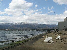
Lake Kamo
Appearance
| Lake Kamo | |
|---|---|
 Lake Kamo and Mount Kimpoku | |
| Coordinates | 38°3′49″N 138°26′12″E / 38.06361°N 138.43667°E |
| Catchment area | 4.85 km2 (1.87 sq mi) |
| Basin countries | Japan |
| Max. length | 4.5 km (2.8 mi) |
| Max. width | 1.5 km (0.93 mi) |
| Surface area | 4.85 km2 (1.87 sq mi)[1] |
| Max. depth | 8.7 m (29 ft) |
| Surface elevation | 0.5 m (1 ft 8 in) |

Lake Kamo (Japanese: 加茂湖, Hepburn: Kamo-ko) is a brackish lake on the Sado Island in the Sea of Japan off the west coast of Honshu, Japan. The lake is the largest of Niigata prefecture.
Originally Lake Kamo was a fresh water lake, but was opened to the sea during the Meiji period to avoid floods, and the water became brackish. The lake is famous for oyster farming, since 1932.[2]
Lake Kamo is ranked among the top 100 Landscapes of Japan.[1]
References
[edit]External links
[edit]- Lake Kamo - Sado Tourism Association

