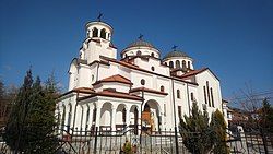
Kulata
Appearance
You can help expand this article with text translated from the corresponding article in Bulgarian. (December 2008) Click [show] for important translation instructions.
|
Kulata
Кулата | |
|---|---|
Village | |
 St. Athanasius Church in the village of Kulata | |
| Coordinates: 41°23′15″N 23°21′50″E / 41.38750°N 23.36389°E | |
| Country | |
| Province | Blagoevgrad |
| Municipality | Petrich |
| Government | |
| • Mayor | Dimitar Manolev (Ind.) |
| Area | |
• Total | 8.27 km2 (3.19 sq mi) |
| Elevation | 105 m (344 ft) |
| Population (2015) | |
• Total | 834 |
| Postal code | 2868 |
| Area code | 07425 |
| Vehicle registration | Е |
41°23′15″N 23°21′50″E / 41.38750°N 23.36389°E

Kulata (Bulgarian: Кулата [ˈkuɫɐtɐ], lit. 'the tower', Greek: Κούλα or Κούλατα) is a village in Petrich Municipality, Blagoevgrad Province, in southwestern Bulgaria. As of 2006[update] it has 892 inhabitants and the mayor is Dimitar Manolev. The village is a major border checkpoint on the border with Greece. The community of Promachonas in Serres regional unit lies across the border.
The first-class European route E79 and the railway from Sofia to Thessaloniki pass through the village. It will be an important stop on the Struma motorway.


