Kolbu
Kolbu | |
|---|---|
Village | |
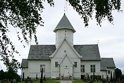
 View of the village church, Kolbu Church | |
| Coordinates: 60°39′01″N 10°44′42″E / 60.65033°N 10.74489°E | |
| Country | Norway |
| Region | Eastern Norway |
| County | Innlandet |
| District | Toten |
| Municipality | Østre Toten Municipality |
| Area | |
• Total | 0.62 km2 (0.24 sq mi) |
| Elevation | 279 m (915 ft) |
| Population (2021)[1] | |
• Total | 648 |
| • Density | 1,049/km2 (2,720/sq mi) |
| Time zone | UTC+01:00 (CET) |
| • Summer (DST) | UTC+02:00 (CEST) |
| Post Code | 2847 Kolbu |
Kolbu is a village in Østre Toten Municipality in Innlandet county, Norway. The village is located in the traditional region of Toten, about 6 kilometres (3.7 mi) to the southwest of the village of Lena, the administrative centre of the municipality. The village lies in the western part of the municipality in an agricultural area, not far from the municipal border with Vestre Toten. Kolbu Church is a cruciform church from 1730 that is located just outside the village centre.[3]
The 0.62-square-kilometre (150-acre) village has a population (2021) of 648 and a population density of 1,049 inhabitants per square kilometre (2,720/sq mi).[1]
History
[edit]Kolbu was the administrative centre of Kolbu Municipality which existed for 56 years (from 1908 when it was split off from Vestre Toten until 1964 when it was merged into Østre Toten).[3]
Name
[edit]The village was named after the old Kolbu farm (Old Norse: Kolabú) since this is where the local church was built. The first element of the name Kol- means "coal" and the last element bú means "house" or "dwelling". The first element is referring to the practice of making coal by burning wood.[4][3]
Schools
[edit]In 2008, the Smeby, Lund, and Moen primary schools merged to form the new Kolbu School (Kolbu Skole). Students graduating from this school usually have to continue their education in Lena upper secondary school.
References
[edit]- ^ a b c Statistisk sentralbyrå (1 January 2021). "Urban settlements. Population and area, by municipality".
- ^ "Kolbu, Østre Toten". yr.no. Retrieved 20 October 2022.
- ^ a b c Thorsnæs, Geir, ed. (29 March 2022). "Kolbu". Store norske leksikon (in Norwegian). Kunnskapsforlaget. Retrieved 20 October 2022.
- ^ Rygh, Oluf (1900). Norske gaardnavne: Kristians amt (in Norwegian) (4 ed.). Kristiania, Norge: W. C. Fabritius & sønners bogtrikkeri. p. 108.


