Kingsmead Viaduct
Kingsmead Viaduct | |
|---|---|
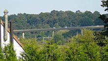
 The Kingsmead Viaduct viewed from the east (downstream) from Ware, approximately 500 metres away | |
| Coordinates | 51°48′34″N 0°03′06″W / 51.8094°N 0.0516°W TL 344 141 |
| Carries | dual 2-lane carriageways |
| Crosses | River Lea, New River, Hertford East branch line |
| Locale | Ware |
| Maintained by | Hertfordshire County Council |
| Characteristics | |
| Design | Concrete Box girder bridge |
| Total length | 35.6 chains (716 m)[1] |
| Height | 65 feet (20 m)[2] |
| No. of spans | 19[2] |
| History | |
| Constructed by | Kier Ltd[2] |
| Construction start | November 1973[2] |
| Construction cost | £3.6 million (£26.5 million in 2020 pounds[3]) |
| Opened | 17 August 1976[2] |
| Location | |
 | |
The Kingsmead Viaduct (or Kings Meads Viaduct[1] is a raised dual-carriageway viaduct of the A10 road on the eastern outskirts of Ware, Hertfordshire, England. It carries the A10 over the River Lea, the New River and the Hertford East branch line.
The road was originally constructed as a trunk route by the Highways Agency as the second part of a two-phase improvement of the A10 between Ware and Cheshunt. On 29 September 2006 the road was de-trunked,[4] and the viaduct is now the responsibility of Hertfordshire County Council.

Major works
[edit]The expansion joints were replaced by the Highways Agency in July 2005.[5]
Improvements to the bridge parapets to bring them up to modern standards were carried out by Hertfordshire Council from July to September 2008.[6]
Location
[edit]The bridge spans the Lea Valley, crossing the River Lea, the New River and the A119 road between the Rush Green Interchange near Hertford and the Westmill interchange (north-west of Ware).
Also running along the valley floor is the Hertford East Branch Line, which the viaduct crosses between Ware and the Hertford East terminus. The viaduct crosses the King's Meads Nature Reserve.[7]
References
[edit]- ^ a b "Trunk Roads". Parliamentary Debates (Hansard). House of Commons. 6 March 2000. col. 459W.
- ^ a b c d e "Ware and Hertford bypass opens". Our Hertford and Ware. Hertfordshire Archives & Local Studies. 29 June 2016. Retrieved 6 March 2022.
- ^ UK Retail Price Index inflation figures are based on data from Clark, Gregory (2017). "The Annual RPI and Average Earnings for Britain, 1209 to Present (New Series)". MeasuringWorth. Retrieved 7 May 2024.
- ^ "Highways Agency Area 6 Newsletter" (PDF). Highways.gov.uk. Highways Agency. Autumn 2006. Archived from the original (PDF) on 22 January 2009. Retrieved 6 March 2022.
- ^ "A10 Kings Mead Viaduct Joint Replacement & Resurfacing". Highways.gov.uk. Highways Agency. Archived from the original on 6 October 2008. Retrieved 30 December 2008.
- ^ "Work begins on Kingsmead Viaduct". hertsdirect.org. Hertfordshire County Council. 4 July 2008. Archived from the original on 5 September 2012. Retrieved 30 December 2008.
- ^ "Map of King's Mead" (PDF). Herts and Middlesex Wildlife Trust. Retrieved 6 March 2022.
