Khoshaba
Appearance
Khoshaba | |
|---|---|
Village | |
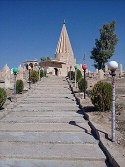
 Yazidi temple in Khoshaba | |
| Coordinates: 36°37′44″N 43°10′35″E / 36.62889°N 43.17639°E | |
| Country | |
| Region | |
| Governorate | Nineveh Governorate (de jure) Dohuk Governorate (de facto) |
| District | Tel Kaif District |
Khoshaba (also written Khawshaba, Arabic: خوشابا; Kurdish: خۆشابا, romanized: Xoşaba)[1][2] is a village located in the Tel Kaif District of the Ninawa Governorate in Iraq. The village is located ca. 20 kilometres (12 mi) southeast of Alqosh and ca. 9 kilometres (5.6 mi) northeast of Telskuf in the Nineveh Plains. It belongs to the disputed territories of Northern Iraq.[3][4]
Khoshaba is populated by Yazidis.[4]
Etymology
Khoshaba comes from the Assyrian-Aramaic word ܚܕܒܫܒܐ khoshaba meaning Sunday.[4][5]
See also
References
- ^ "خۆشابا:هۆلا بیرەوەرییان پێتڤی كەلوپەلانە" (in Kurdish). Archived from the original on 13 April 2020. Retrieved 19 December 2019.
- ^ "Bi çavdêrya berêz"Şêx Şamo" qenepe bo holên laliş li Gundên Xoşaba û Doxata hatine dabînkirin". Bingehê Laliş (in Kurdish). Archived from the original on 19 December 2019. Retrieved 19 December 2019.
- ^ Saadi Azuo, Heerish (June 2016). "Graduate school of social sciences general psychology master's programme: Post-traumatic stress disorder among Ezidian women who escaped from ISIS capture" (PDF). Near East University. Retrieved 2018-12-05.
- ^ a b c "The Struggle to Exist - Part I: An Introduction to the Assyrians and their Human Rights Situation in the New Iraq" (PDF). Assyria Council of Europe, Hammurabi Human Rights Organization. February 2010. Retrieved 2018-12-05.
- ^ "Search Entry". www.assyrianlanguages.org. Retrieved 2022-05-08.


