Khorixas
Khorixas | |
|---|---|
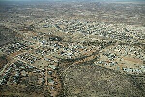
 Aerial view of Khorixas (2018) | |
| Coordinates: 20°22′S 14°58′E / 20.367°S 14.967°E | |
| Country | |
| Region | Kunene Region |
| Constituency | Khorixas Constituency |
| Government | |
| • Mayor | Cloephas Tjunduwa |
| • Town Council CEO | Lina ǂGaeses |
| Population | |
• Total | 9,371 |
| Time zone | UTC+2 (CAT) |
| Climate | BSh |


Khorixas is a town with about 9,000 inhabitants in the southern part of the Kunene Region, Namibia. It was the capital of the Damaraland bantustan before Namibia's independence.[3] It is the administrative capital of Khorixas Constituency. Most of the inhabitants are from the Damara ethnic group. The town is located near the Petrified Forest, a deposit of petrified wood and well known tourist attraction of Namibia. The Twyfelfontein valley, known for its rock art, is also accessible from Khorixas.
Economy and infrastructure
[edit]
Khorixas suffers[update] from a lack of economic development and employment opportunities, which leads to frustration and outward migration among many of the town's youth.[4] The unemployment rate in town is estimated to be around 70%. Donkerhoek (Afrikaans: dark corner), the town's informal settlement, has neither water nor electricity.[5]
The regional hospital and some other regional offices are located in Khorixas, though the capital of the Kunene Region is Opuwo. Khorixas has a landing strip nine kilometers east of town parallel to the C39 main road. The Runway Numbers are 09/27 and elevation is 3320 feet.
There are six schools and one branch of the University of Namibia (UNAM) in Khorixas, Versteendewoud is the biggest primary school and Cornelius Goreseb High School is the biggest secondary school. Other schools are: Eddie Bowe Primary School, Welwitchia Primary School, Welwitchia Junior Secondary School and Th. F. ǃGaeb Primary School.
Politics
[edit]Khorixas is governed by a town council that has seven seats.[6] Due to its location in former Damaraland, the ethnically Damara-based United Democratic Front (UDF) has strong support in the population. Unlike in most other constituencies of Namibia, the ruling SWAPO party had until 2015 never won in Khorixas.[7]
Local authority elections
[edit]The 2015 local authority election was won by SWAPO, gaining four seats (1,741 votes) and the majority in the village council. The remaining three seats went to the UDF with 1,345 votes.[8] The 2020 local authority election was won by the UDF which gained 985 votes and four seats. SWAPO was runner up with 624 votes and two seats. The remaining seat went to the Landless People's Movement (LPM, a new party registered in 2018, 261 votes).[9]
Mayors
[edit]- 1992-2002 Chief Gottfried Arusen Uiseb, UDF. First Mayor of Khorixas until his death in 2002.
- 2005 Martha Claassen, UDF. Claassen was the first female mayor of Khorixas but her reign lasted only three days.[10]
- 2012–2015 Trypohasa Moloto, UDF.[10]
- 2015–2020: Elizabeth Geises, SWAPO
Geography
[edit]Climate
[edit]Khorixas has a semi-arid climate (BSh, according to the Köppen climate classification), with warm to hot summers and mild winters. It borders on a desert climate (BWh). The average annual precipitation is 220 mm (9 in), with a low of 106 mm (4.2 in) during the 2010s drought in 2018/19.[11]
| Khorixas | ||||||||||||||||||||||||||||||||||||||||||||||||||||||||||||
|---|---|---|---|---|---|---|---|---|---|---|---|---|---|---|---|---|---|---|---|---|---|---|---|---|---|---|---|---|---|---|---|---|---|---|---|---|---|---|---|---|---|---|---|---|---|---|---|---|---|---|---|---|---|---|---|---|---|---|---|---|
| Climate chart (explanation) | ||||||||||||||||||||||||||||||||||||||||||||||||||||||||||||
| ||||||||||||||||||||||||||||||||||||||||||||||||||||||||||||
| ||||||||||||||||||||||||||||||||||||||||||||||||||||||||||||
Sport
[edit]The Robber Chanties, which in August 2010 played in the Northern Stream Division One and sought promotion the Namibia Premier League, are based in Khorixas.[12]
Sights
[edit]References
[edit]- ^ "Table 4.2.2 Urban population by Census years (2001 and 2011)" (PDF). Namibia 2011 - Population and Housing Census Main Report. Namibia Statistics Agency. p. 39. Retrieved 24 August 2016.
- ^ "2023 Population & Housing Census Preliminary Report" (PDF). Statistics Namibia.
- ^ Khorixas Journal; For Apartheid's Castaways, Heartbreak in Desert New York Times, July 7, 1989
- ^ Khorixas: A town on a downward spiral The Namibian, 10 August 2009
- ^ Kapitako, Alvine (24 April 2015). "Jobs simply scarce in Khorixas". New Era. p. 6.
- ^ "Know Your Local Authority". Election Watch. No. 3. Institute for Public Policy Research. 2015. p. 4.
- ^ "UDF's mediocrity led to Swapo victory - ǁGaroëb". New Era. 3 December 2015.
- ^ "Local elections results". Electoral Commission of Namibia. 28 November 2015. p. 4. Archived from the original on 10 December 2015.
- ^ "2020 Local Authority Elections Results and Allocation of Seats" (PDF). Electoral Commission of Namibia. 29 November 2020. p. 10. Archived from the original (PDF) on 24 January 2021. Retrieved 26 January 2021.
- ^ a b Miyanicwe, Clemans (28 November 2012). "Khorixas elects young mayor". The Namibian. Archived from the original on 21 February 2013.
- ^ Menges, Werner; Oliveira, Yokany (23 May 2019). "Khomas faces worst drought in 90 years". The Namibian. p. 1.
- ^ Chanties cry foul over unwanted whistle blower New Era, 5 August 2010

