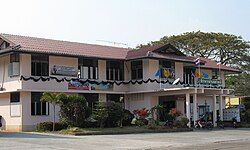
Khamcha-i district
Khamcha-i
คำชะอี | |
|---|---|
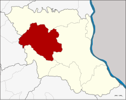
 District location in Mukdahan province | |
| Coordinates: 16°34′38″N 104°25′9″E / 16.57722°N 104.41917°E | |
| Country | |
| Province | Mukdahan |
| Seat | Nam Thiang |
| District established | 1941 |
| Area | |
• Total | 645.7 km2 (249.3 sq mi) |
| Population (2005) | |
• Total | 46,987 |
| • Density | 72.8/km2 (189/sq mi) |
| Time zone | UTC+7 (ICT) |
| Postal code | 49110 |
| Geocode | 4905 |
Khamcha-i (Thai: คำชะอี) is a district (amphoe) of Mukdahan province, northeastern Thailand.
Geography
[edit]Neighboring districts are (from the north clockwise) Dong Luang, Mueang Mukdahan, and Nong Sung of Mukdahan Province; Kuchinarai and Khao Wong of Kalasin province.
History
[edit]The minor district (king amphoe) was created on 24 June 1941, when the six tambons Khamcha-i, Nong Sung, Ban Song, Ban Kho, Ban Lao, and Nong Ian were split off from Mukdahan District.[1] Originally the district office was in Khamcha-i Sub-district, but in 1949 it was moved to Ban Song Sub-district.[2] In 1956 the minor district was upgraded to a full district.[3] In 1982 it was one of the districts which formed then new province Mukdahan.
Administration
[edit]The district is divided into nine sub-districts (tambons), which are further subdivided into 87 villages (muban). Khamcha-i is a sub-district municipality (thesaban tambon), which covers parts of tambon Nam Thiang. There are a further nine tambon administrative organizations (TAO).

| No. | Name | Thai | Villages | Pop.[4] |
|---|---|---|---|---|
| 3. | Ban Song | บ้านซ่ง | 7 | 4,105 |
| 4. | Khamcha-i | คำชะอี | 13 | 6,892 |
| 5. | Nong Ian | หนองเอี่ยน | 10 | 5,387 |
| 6. | Ban Kho | บ้านค้อ | 11 | 7,101 |
| 7. | Ban Lao | บ้านเหล่า | 11 | 5,652 |
| 8. | Phon Ngam | โพนงาม | 10 | 5,227 |
| 11. | Lao Sang Tho | เหล่าสร้างถ่อ | 7 | 3,939 |
| 12. | Kham Bok | คำบก | 6 | 2,506 |
| 14. | Nam Thiang | น้ำเที่ยง | 12 | 6,299 |
Missing numbers are tambon which now form Nong Sung District.
References
[edit]- ^ ประกาศกระทรวงมหาดไทย เรื่อง ตั้งกิ่งอำเภอคำชะอี ขึ้นอำเภอมุกดาหาร จังหวัดนครพนม (PDF). Royal Gazette (in Thai). 58 (ง): 1264–1265. May 20, 1941. Archived from the original (PDF) on May 10, 2012.
- ^ ประกาศกระทรวงมหาดไทย เรื่อง การย้ายที่ว่าการกิ่งอำเภอคำชะอี อำเภอมุกดาหาร จังหวัดนครพนม (PDF). Royal Gazette (in Thai). 66 (65 ง): 5297–5298. 1949-11-29. Archived from the original (PDF) on June 9, 2012.
- ^ พระราชกฤษฎีกาจัดตั้งอำเภอนาทวี อำเภอสะบ้าย้อย อำเภอคำชะอี อำเภอย่านตาขาว อำเภอวัดโบสถ์ อำเภอหนองบัว อำเภอวัฒนานคร อำเภอแสวงหา อำเภอท่าชนะ อำเภอพระพุทธบาท อำเภอโนนสัง อำเภอบำเหน็จณรงค์ อำเภอคอนสวรรค์ อำเภอบ้านโฮ่ง อำเภอคีรีมาศ อำเภอชนแดน อำเภอแม่แจ่ม อำเภอไทรน้อย และอำเภอบ้านแพง พ.ศ. ๒๔๙๙ (PDF). Royal Gazette (in Thai). 73 (46 ก): 657–661. June 5, 1956. Archived from the original (PDF) on October 11, 2011.
- ^ "Population statistics 2008". Department of Provincial Administration. Archived from the original on 2009-09-17.
External links
[edit]
