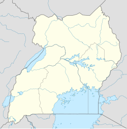
Katakwi
Katakwi | |
|---|---|
| Coordinates: 01°54′54″N 33°57′18″E / 1.91500°N 33.95500°E | |
| Country | Uganda |
| Region | Eastern Region of Uganda |
| Sub-region | Teso sub-region |
| District | Katakwi District |
| Elevation | 1,100 m (3,600 ft) |
| Population (2020 Estimate) | |
• Total | 9,100 |
| Time zone | UTC+3 (EAT) |
Katakwi is a town in the Eastern Region of Uganda. It is the main municipal, administrative, and commercial center of Katakwi District and the site of the district headquarters.[1]
Location
[edit]Katakwi is approximately 52 kilometres (32 mi), by road, northeast of Soroti, the largest city in the Teso sub-region.[2] It is about 153 kilometres (95 mi), by road, northwest of Mbale, the largest city in Uganda's Eastern Region.[3] Katakwi is approximately 343 kilometres (213 mi), by road, northeast of Kampala, the capital of Uganda and its largest city.[4] The coordinates of the town are 01°54'54.0"N, 33°57'18.0"E (Latitude:1.9150; Longitude:33.9550).[5]
Population
[edit]The 2002 national census estimated the town's population at 5,900. In 2010, the Uganda Bureau of Statistics (UBOS) estimated the population at 8,100. In 2011, the UBOS estimated the population at 8,400 people.[6]
In 2015 the population of the town was projected at 8,000. In 2020 the mid-year population of Katakwi Town Council was projected at 9,100. It was calculated that the population of the town had increased at an average annual rate of 2.6 percent between 2015 and 2020.[7]
| Year | Pop. | ±% |
|---|---|---|
| 2002 | 5,900 | — |
| 2010 | 8,100 | +37.3% |
| 2011 | 8,400 | +3.7% |
| 2015 | 8,000 | −4.8% |
| 2020 | 9,100 | +13.7% |
| source:[6][7] | ||
Points of interest
[edit]The following additional points of interest lie within the town limits or close to the edges of town: (1) Stanbic Bank Uganda Limited maintains a branch in town[8] (2) the offices of Katakwi Town Council (3) Katakwi central market (4) Katakwi General Hospital, a public hospital administered by the Uganda Ministry of Health (5) the Soroti–Katakwi–Moroto–Lokitanyala Road passes through the middle of town.[5]
See also
[edit]References
[edit]- ^ John Ogulei (15 July 2021). "Katakwi Town Council Officials on spot over Garbage Collection". The Tower Post. Kampala. Retrieved 9 August 2022.
- ^ "Road Distance Between Soroti, Eastern Region, Uganda And Katakwi, Eastern Region, Uganda" (Map). Google Maps. Retrieved 9 August 2022.
- ^ "Road Distance Between Mbale, Eastern Region, Uganda And Katakwi, Eastern Region, Uganda" (Map). Google Maps. Retrieved 9 August 2022.
- ^ "Road Distance Between Kampala, Central Region, Uganda And Katakwi, Eastern Region, Uganda" (Map). Google Maps. Retrieved 9 August 2022.
- ^ a b "Location of Katakwi Town, Eastern Region, Uganda" (Map). Google Maps. Retrieved 9 August 2022.
- ^ a b Uganda Bureau of Statistics (June 2011). "Estimated Population of Katakwi In 2002, 2010 And 2011" (PDF). Uganda Bureau of Statistics. Kampala, Uganda. Archived from the original (Archived from the original on 7 July 2014) on 7 July 2014. Retrieved 9 August 2022.
- ^ a b Citypopulaton.de (14 June 2020). "The population development of Katakwi Town Council as well as related information and services" (Source: Uganda Bureau of Statistics). Citypopulation.de. Retrieved 9 August 2022.
- ^ "Location of Stanbic Bank Uganda Limited: Katakwi Branch" (Map). Google Maps. Retrieved 13 May 2016.
External links
[edit]


