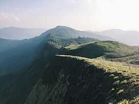
Kapamüdzü
Appearance
| Kapamüdzü | |
|---|---|
 | |
| Highest point | |
| Elevation | 2,620 m (8,600 ft) |
| Coordinates | 25°19′N 94°10′E / 25.31°N 94.17°E |
| Geography | |
| Location | Zhavame, Phek District, Nagaland, India |
Kapamüdzü, is a mountain peak in the Phek District of the Indian state of Nagaland.[1] Standing at an elevation of 2,620 m (8,596 ft), it is the fourth highest peak in Nagaland and also the highest table top mountain in the state.[2]
Gallery
[edit]References
[edit]- ^ "Hike to Kapamodzü Peak under Phek District". Nagaland Tourism. 28 August 2020. Retrieved 6 November 2022.
- ^ "When in Nagaland, check out these 5 trekking destinations". East Mojo. 14 January 2020. Retrieved 6 November 2022.
External links
[edit]Wikimedia Commons has media related to Kapamüdzü.


