Kačice
Kačice | |
|---|---|
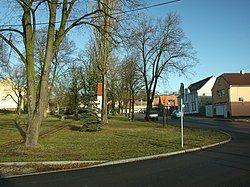
 Centre of Kačice | |
| Coordinates: 50°9′46″N 13°59′18″E / 50.16278°N 13.98833°E | |
| Country | |
| Region | Central Bohemian |
| District | Kladno |
| First mentioned | 1318 |
| Area | |
• Total | 6.43 km2 (2.48 sq mi) |
| Elevation | 388 m (1,273 ft) |
| Population (2024-01-01)[1] | |
• Total | 1,245 |
| • Density | 190/km2 (500/sq mi) |
| Time zone | UTC+1 (CET) |
| • Summer (DST) | UTC+2 (CEST) |
| Postal code | 273 04 |
| Website | www |
Kačice is a municipality and village in Kladno District in the Central Bohemian Region of the Czech Republic. It has about 1,200 inhabitants.
Etymology
[edit]The surname of the first inhabitant of the village was probably Kačice and the village was named after him. The surname was derived from the feminine name Káča, Kačena (variation of the name Kateřina, Czech form of Catherine) or from of the Old Czech word kačice ('duck').[2]
Geography
[edit]Kačice is located about 8 kilometres (5 mi) west of Kladno and 27 km (17 mi) northwest of Prague. It lies in the Džbán range. The highest point is at 435 m (1,427 ft) above sea level. The Loděnice River flows along the southwestern municipal border.
History
[edit]The first written mention of Kačice is from 1318. Until 1550, it was owned by various lower noblemen. In 1550–1551, both parts of Kačice were bought by the Martinic family and annexed to the Smečno estate.[3]
Demographics
[edit]
|
|
| ||||||||||||||||||||||||||||||||||||||||||||||||||||||
| Source: Censuses[4][5] | ||||||||||||||||||||||||||||||||||||||||||||||||||||||||
Transport
[edit]The D6 motorway from Prague to Karlovy Vary runs south of the village, just outside the municipal territory.
Kačice is located on the railway line Kladno–Rakovník.[6]
Sights
[edit]
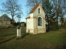
There are no major historical monuments in the municipality. The main landmark is the Chapel of Saint John of Nepomuk. It is a small pseudo-Gothic niche chapel, dating from 1851. Next to the chapel is a cast iron cross.[7] Other protected cultural monuments are a statue of a bishop from the first half of the 18th century and a rural homestead from the turn of the 18th and 19th centuries.[8]
References
[edit]- ^ "Population of Municipalities – 1 January 2024". Czech Statistical Office. 2024-05-17.
- ^ Profous, Antonín (1949). Místní jména v Čechách II: CH–L (in Czech). p. 176.
- ^ "Historie obce" (in Czech). Obec Kačice. Retrieved 2024-05-21.
- ^ "Historický lexikon obcí České republiky 1869–2011" (in Czech). Czech Statistical Office. 2015-12-21.
- ^ "Population Census 2021: Population by sex". Public Database. Czech Statistical Office. 2021-03-27.
- ^ "Detail stanice Kačice" (in Czech). České dráhy. Retrieved 2024-05-21.
- ^ "Pamětihodnosti a pomníky" (in Czech). Obec Kačice. Retrieved 2024-05-21.
- ^ "Výsledky vyhledávání: Kulturní památky, obec Kačice". Ústřední seznam kulturních památek (in Czech). National Heritage Institute. Retrieved 2024-08-26.


