Iziaslav, Ukraine
Iziaslav
Ізяслав | |
|---|---|
| |
Location of Iziaslav within Khmelnytskyi Oblast and Ukraine | |
| Coordinates: 50°07′00″N 26°48′00″E / 50.11667°N 26.80000°E | |
| Country | |
| Oblast | Khmelnytskyi Oblast |
| Raion | Shepetivka Raion |
| Hromada | Iziaslav urban hromada |
| First mention date | 1390 |
| City rights | 1583 |
| Government | |
| • Mayor | Valentyna Korniichuk[1] |
| Area | |
• Total | 23.91 km2 (9.23 sq mi) |
| Population (2022) | |
• Total | 15,996 |
| • Density | 670/km2 (1,700/sq mi) |
| Demonym | Zaslavian |
| Time zone | UTC+2 (EET) |
| • Summer (DST) | UTC+3 (EEST) |
| Postal code | 30300 |
| Area code | +3803852 |
| Website | http://izyaslav.miskrada.org.ua/ |
Iziaslav (Ukrainian: Ізяслав, IPA: [iˈzʲɑslɐu̯]), also spelled Izyaslav or Zaslav (Ukrainian: Заслав, IPA: [ˈzɑslɐu̯]; Polish: Zasław, IPA: [ˈzaswaf]) is one of the oldest cities in Volhynia. Situated on the Horyn River in western Ukraine, the city dates back to the 11th century.[2] Iziaslav belongs to Shepetivka Raion of Khmelnytskyi Oblast. It hosts the administration of Iziaslav urban hromada, one of the hromadas of Ukraine.[3] Population: 15,296 (2022 estimate).[4]
History
[edit]Izyaslav was first mentioned in 1390. It was a private town in Poland, owned by the Zasławski and Sanguszko families. It was part of the Polish Volhynian Voivodeship. In 1583 it was granted Magdeburg city rights.
After the Partitions of Poland Iziaslav was part of the Russian Empire – Volhynian Governorate.
At the beginning of World War II, the town had a Jewish population representing 28% of the inhabitants.[5] As soon as the Germans occupied the town, Jews were kept imprisoned in a ghetto and were later murdered in mass executions perpetrated by Einsatzgruppen.[6]
Until 18 July 2020, Iziaslav was the administrative center of Iziaslav Raion. The raion was abolished in July 2020 as part of the administrative reform of Ukraine, which reduced the number of raions of Khmelnytskyi Oblast to three. The area of Iziaslav Raion was merged into Shepetivka Raion.[7][8]
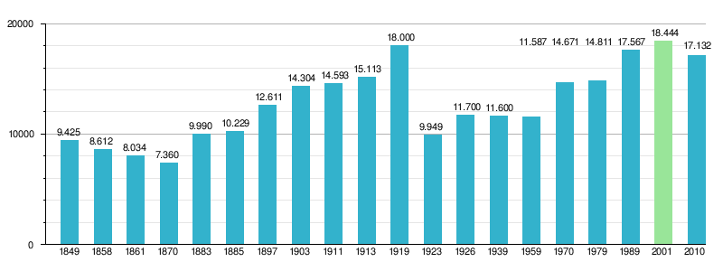
Historical demographics of Iziaslav
[edit]
Monuments
[edit]-
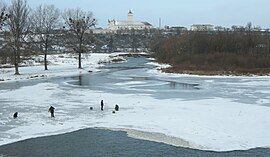
City view
-
Old Zaslav Castle
-
Ruins of Sanguszko Palace
-
Church of St. Michael and Bernardine Monastery
-
Church of St. Joseph and Lazarists Monastery
-
Church of Nativity
-
Horyn River in the city
-
St. John Cathedral
- Starozaslavsky Castle
- Novozaslavsky Castle
- St. John Cathedral
- Great Synagogue
- Church of St. Michael and Bernardine monastery
- Church of St. Joseph and Lazarists monastery
- Lazarists Hospital
- Palace of Sanguszko
- Cloth Hall
- Novozaslavsky Synagogue
Notable people
[edit]- Anatoliy Aleksandrov (born 1951), rector of the Bauman University, Moscow
- Dmytro Chyhrynskyi (born 1986), Ukrainian professional footballer
- Marian Karol Dubiecki (1838–1926), Polish historian
- Paolo Fontana (1696–1765), Italian-Polish Baroque architect
- Nathan ben Moses Hannover (17th century), Ruthenian Jewish historian, Talmudist, and kabbalist
- Bill Mazer (1920–2013), American television and radio personality
- Eugene Nakonechny (b. 1914 in Iziaslav; d. 1988 in the US), architect and artist
- Leonard Nimoy (1931–2015), American actor (played Spock in Star Trek); parents born in Iziaslav, emigrated to Boston, USA
- Myroslav Popovych (1930–2018), Ukrainian philosopher
- Tzvi Tzur (1923–2004), Israeli officer, IDF Chief of Staff (1961–1963)
- Aleksander Zasławski (died 1629), Polish-Lithuanian noble, voivode of Bracław
- Władysław Dominik Zasławski (c. 1616–1656), Polish nobleman of Ruthenian stock, prince of the princely houses of Poland
References
[edit]- ^ "Біографія | Ізяславська громада, Хмельницька область, Шепетівський район".
- ^ Михайло Нікітенко. Знайдено давньоруський город на Волині // "Золоті ворота" № 3, 1994, с. 6-14; Його ж: До питання про літописний Ізяславль: нові археологічні дані. // Велика Волинь: минуле й сучасне. Хмельницький — Ізяслав — Шепетівка, 1994. с. 237—239 (in Ukrainian).
- ^ "Изяславская городская громада" (in Russian). Портал об'єднаних громад України.
- ^ Чисельність наявного населення України на 1 січня 2022 [Number of Present Population of Ukraine, as of January 1, 2022] (PDF) (in Ukrainian and English). Kyiv: State Statistics Service of Ukraine. Archived (PDF) from the original on 4 July 2022.
- ^ "Izyaslav Kehilalinks Home Page".
- ^ "Yahad – in Unum".
- ^ "Про утворення та ліквідацію районів. Постанова Верховної Ради України № 807-ІХ". Голос України (in Ukrainian). 2020-07-18. Retrieved 2020-10-03.
- ^ "Нові райони: карти + склад" (in Ukrainian). Міністерство розвитку громад та територій України. 17 July 2020.
External links
[edit] Media related to Iziaslav at Wikimedia Commons
- Zaslav in Internet Encyclopedia of Ukraine
- Iziaslav Castle
- International Association of Jewish Genealogical Societies (Izyaslav, Ukraine)
- The murder of the Jews of Iziaslav during World War II, at Yad Vashem website.


